IMAGES TAKEN NEAR TO
Tofthill Place, PERTH, PH2 7TW
Introduction
This page details the photographs taken nearby to Tofthill Place, PH2 7TW by members of the Geograph project.
The Geograph project started in 2005 with the aim of publishing, organising and preserving representative images for every square kilometre of Great Britain, Ireland and the Isle of Man.

There are currently over 7.5m images from over14,400 individuals and you can help contribute to the project by visiting https://www.geograph.org.uk
Image Map (Loading...)


Getting Data...Please wait
Leaflet Map data © OpenStreetMap
Images are licensed for reuse under creativecommons.org/licenses/by-sa/2.0
Notes
- Clicking on the map will re-center to the selected point.
- The higher the marker number, the further away the image location is from the centre of the postcode.
Image Listing (17 Images Found)
Images are licensed for reuse under creativecommons.org/licenses/by-sa/2.0
Image
Details
Distance
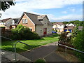
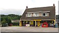
3

Madoch Square
Recent housing development in St Madoes.
Image: © Richard Webb
Taken: 25 Aug 2010
0.13 miles
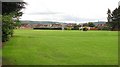
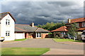
4
Children's play area
This recently-built estate at St Madoes has a good large green in the centre.
Image: © Rob Burke
Taken: 26 Nov 2005
0.15 miles

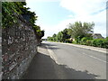
7
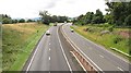
A90 (A85)
Renamed A90 as a consistent number from Edinburgh to Aberdeen, this is the main road from Dundee and Aberdeen to the Central Belt. View from an overbridge between Glencarse and St Madoes.
Image: © Richard Webb
Taken: 25 Aug 2010
0.19 miles
10
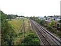
Railway, St Madoes
The Perth to Dundee railway beside the A90.
Image: © Richard Webb
Taken: 30 Aug 2014
0.21 miles