IMAGES TAKEN NEAR TO
Errol, PERTH, PH2 7TB
Introduction
This page details the photographs taken nearby to PH2 7TB by members of the Geograph project.
The Geograph project started in 2005 with the aim of publishing, organising and preserving representative images for every square kilometre of Great Britain, Ireland and the Isle of Man.

There are currently over 7.5m images from over14,400 individuals and you can help contribute to the project by visiting https://www.geograph.org.uk
Image Map
Images are licensed for reuse under creativecommons.org/licenses/by-sa/2.0
Notes
- Clicking on the map will re-center to the selected point.
- The higher the marker number, the further away the image location is from the centre of the postcode.
Image Listing (5 Images Found)
Images are licensed for reuse under creativecommons.org/licenses/by-sa/2.0
Image
Details
Distance
1
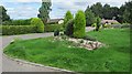
Bungalows, Grange
Maturing housing development in Grange.
Image: © Richard Webb
Taken: 25 Aug 2010
0.09 miles
2
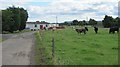
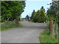
Errol Airfield
Access road to Errol Airfield.
Image: © Richard Webb
Taken: 25 Aug 2010
0.11 miles
3
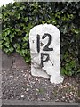
Old Milestone in Grange, near Firth of Tay
Milestone by the UC road, in parish of Errol (Perth and Kinross District), Grange, West end, end of 2 white cottages West of bend.
Inscription reads:-
12
P
(To Perth)
Surveyed
Milestone Society National ID: PK_PTDDUC12
Image: © Milestone Society
Taken: Unknown
0.16 miles
4
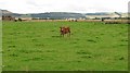
Errol Airfield
Cattle graze amongst relics of a wartime airfield on the Carse of Gowrie. The airfield is still in use for parachuting.
Image: © Richard Webb
Taken: 25 Aug 2010
0.20 miles
5
Entrance to sawmill at Muirhouses
North of Leys in Perth and Kinross.
Image: © James Denham
Taken: 2 Jun 2010
0.25 miles