IMAGES TAKEN NEAR TO
Rait, PERTH, PH2 7SE
Introduction
This page details the photographs taken nearby to PH2 7SE by members of the Geograph project.
The Geograph project started in 2005 with the aim of publishing, organising and preserving representative images for every square kilometre of Great Britain, Ireland and the Isle of Man.

There are currently over 7.5m images from over14,400 individuals and you can help contribute to the project by visiting https://www.geograph.org.uk
Image Map
Images are licensed for reuse under creativecommons.org/licenses/by-sa/2.0
Notes
- Clicking on the map will re-center to the selected point.
- The higher the marker number, the further away the image location is from the centre of the postcode.
Image Listing (6 Images Found)
Images are licensed for reuse under creativecommons.org/licenses/by-sa/2.0
Image
Details
Distance
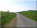
1
Gorse flowers and bullocks
Looking east from the road to Kilspindie. The house on the far side of the field is set back from the road and sheltered by trees.
Image: © Lis Burke
Taken: 22 Jan 2006
0.11 miles
3
Field rubble, Dalreichmoor
Rocks and other rubble from this field have been gathered into a hollow allowing the remainder of the field to be worked at the loss of what was, in any event, an area of poor land.
Image: © Alpin Stewart
Taken: 5 Apr 2014
0.20 miles
4
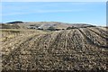
Stubble, Dalreichmoor
Arable land in the Sidlaw Hills and the remains of last year's barley crop.
Image: © Richard Webb
Taken: 8 Feb 2015
0.22 miles
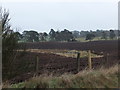
5
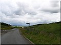
Rait to Balbeggie road at the Kilspindie junction
Image: © Elliott Simpson
Taken: 1 Aug 2015
0.24 miles