IMAGES TAKEN NEAR TO
Rait, PERTH, PH2 7RY
Introduction
This page details the photographs taken nearby to PH2 7RY by members of the Geograph project.
The Geograph project started in 2005 with the aim of publishing, organising and preserving representative images for every square kilometre of Great Britain, Ireland and the Isle of Man.

There are currently over 7.5m images from over14,400 individuals and you can help contribute to the project by visiting https://www.geograph.org.uk
Image Map
Images are licensed for reuse under creativecommons.org/licenses/by-sa/2.0
Notes
- Clicking on the map will re-center to the selected point.
- The higher the marker number, the further away the image location is from the centre of the postcode.
Image Listing (9 Images Found)
Images are licensed for reuse under creativecommons.org/licenses/by-sa/2.0
Image
Details
Distance
2
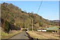
Road near Fingask
A road runs along the foot of the Sidlaw Hills.
Image: © Richard Webb
Taken: 8 Feb 2015
0.08 miles
3
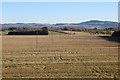
Stubble, Flawcraig
Arable land, Carse of Gowrie.
Image: © Richard Webb
Taken: 8 Feb 2015
0.12 miles
5
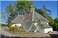
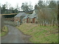
North Lodge at Fingask
This lodge is marked on the map as 'North Lodge' which is curious, because it is south of Fingask Castle. It also has a name plate saying 'Fingask Lodge'. Also curious is the curved feature on the side elevation. My first thought was that it is an old toll house, but if so, the windows it must have had have been built up, making the whole north elevation windowless.
Edit: I am grateful to Ailsa Macmillan who has sent me additional information about the house. She writes, "It was built as a Lodge House for Fingask Castle- I can't find the exact dates but somewhere between 1818 when the entrance to the castle was moved (it does not appear on a copy of the estate map of that date held by the AK Bell Library) and 1826 when it does appear on an OS map. I estimate therefore the house was built somewhere around 1820.
It is and has always been called North Lodge as it is at the top of a long lane, now pretty rutted which leads all the way down to the A9. South Lodge, which is now derelict, can be seen from the road and is on the Buildings at Risk register.
I understand that it was possible to buy a book of plans off the shelf at the time North Lodge was built and it may well be that the owners of the time liked the idea of the curved wall, although it would have been more difficult to build from field stone."
Image: © Anne Burgess
Taken: 8 May 2017
0.20 miles
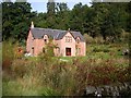
7
Sir Stuart's House, Fingask
A cottage on the Fingask estate, rented out for holidays. It is a newly built house, completed in 2003, but on the site of an older building. It is named for Sir Stuart Threipmuir, ancestor of the current owner, and physician to Bonnie Prince Charlie.
Image: © Mike Pennington
Taken: 11 Oct 2008
0.22 miles
8
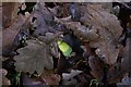
Underneath the oak tree in autumn, Fingask
A newly fallen acorn among brown oak leaves.
Image: © Mike Pennington
Taken: 12 Oct 2008
0.23 miles
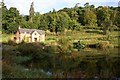
9
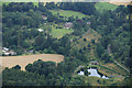
Fingask Castle and grounds from the air
Taken from a hot air balloon over fields east of Rait. Sir Stuart's House and the pond bottom left and the castle top centre.
Image: © Mike Pennington
Taken: 14 Aug 2013
0.24 miles