IMAGES TAKEN NEAR TO
Pitroddie, PERTH, PH2 7RJ
Introduction
This page details the photographs taken nearby to PH2 7RJ by members of the Geograph project.
The Geograph project started in 2005 with the aim of publishing, organising and preserving representative images for every square kilometre of Great Britain, Ireland and the Isle of Man.

There are currently over 7.5m images from over14,400 individuals and you can help contribute to the project by visiting https://www.geograph.org.uk
Image Map
Images are licensed for reuse under creativecommons.org/licenses/by-sa/2.0
Notes
- Clicking on the map will re-center to the selected point.
- The higher the marker number, the further away the image location is from the centre of the postcode.
Image Listing (8 Images Found)
Images are licensed for reuse under creativecommons.org/licenses/by-sa/2.0
Image
Details
Distance
1
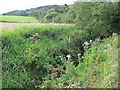
Pitroddie Burn
Dense vegetation alongside the burn. A hill burn hitting a plain suddenly will deposit a lot of material and cause flooding. The burn here has been tamed by digging a deep ditch across the carse land.
Image: © Richard Webb
Taken: 25 Aug 2010
0.07 miles
2
Agricultural building at Pitroddie Farm
Image: © Dave Fergusson
Taken: 27 Sep 2010
0.14 miles
3

Agricultural machinery at Pitroddie Farm
Image: © Dave Fergusson
Taken: 27 Sep 2010
0.15 miles
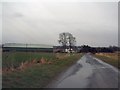
4
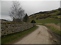
Minor road by Pitroddie Farm
Sheep grazing on the hill in the centre background.
Image: © Douglas Nelson
Taken: 12 Mar 2017
0.20 miles
5
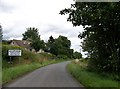
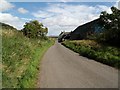
Approaching Kilspindie from the south
Image: © Elliott Simpson
Taken: 1 Aug 2015
0.22 miles
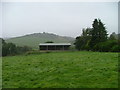
6
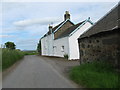
Pitroddie Farm
The white building is the farm house.
Image: © James Denham
Taken: 2 Jun 2010
0.23 miles