IMAGES TAKEN NEAR TO
Rait Road, PERTH, PH2 7PP
Introduction
This page details the photographs taken nearby to Rait Road, PH2 7PP by members of the Geograph project.
The Geograph project started in 2005 with the aim of publishing, organising and preserving representative images for every square kilometre of Great Britain, Ireland and the Isle of Man.

There are currently over 7.5m images from over14,400 individuals and you can help contribute to the project by visiting https://www.geograph.org.uk
Image Map
Images are licensed for reuse under creativecommons.org/licenses/by-sa/2.0
Notes
- Clicking on the map will re-center to the selected point.
- The higher the marker number, the further away the image location is from the centre of the postcode.
Image Listing (9 Images Found)
Images are licensed for reuse under creativecommons.org/licenses/by-sa/2.0
Image
Details
Distance
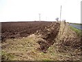
2
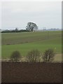
Ploughed field
Looking north to sown fields beyond.
Image: © Rob Burke
Taken: 22 Jan 2006
0.11 miles
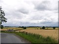
4
Arable land, Boghall
Strathmore farmland.
Image: © Richard Webb
Taken: 8 Feb 2015
0.15 miles
5
Ploughed Field
Looking west across a recently ploughed field.
Image: © Lis Burke
Taken: 22 Jan 2006
0.15 miles
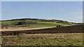
6
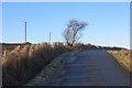
Rait to Balbeggie Road
A crossing of the Sidlaw Hills.
Image: © Richard Webb
Taken: 8 Feb 2015
0.17 miles
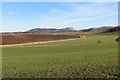
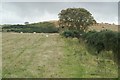
7
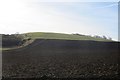
Slopes of Shien Hill
Arable land above the road between Balbeggie and Rait in the Sidlaw Hills.
Image: © Richard Webb
Taken: 8 Feb 2015
0.21 miles
8
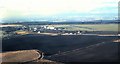
View towards Perth Aerodrome
from near Boghall.
Image: © Stanley Howe
Taken: Unknown
0.23 miles
9
Northern slopes of Shien Hill, near Balbeggie
The northern edge of the Sidlaw Hills; gentle enough and low-lying enough to have cereal crops growing on some of the summits.
Image: © Mike Pennington
Taken: 10 Oct 2008
0.25 miles