IMAGES TAKEN NEAR TO
PERTH, PH2 7PG
Introduction
This page details the photographs taken nearby to PH2 7PG by members of the Geograph project.
The Geograph project started in 2005 with the aim of publishing, organising and preserving representative images for every square kilometre of Great Britain, Ireland and the Isle of Man.

There are currently over 7.5m images from over14,400 individuals and you can help contribute to the project by visiting https://www.geograph.org.uk
Image Map (Loading...)


Getting Data...Please wait
Leaflet Map data © OpenStreetMap
Images are licensed for reuse under creativecommons.org/licenses/by-sa/2.0
Notes
- Clicking on the map will re-center to the selected point.
- The higher the marker number, the further away the image location is from the centre of the postcode.
Image Listing (10 Images Found)
Images are licensed for reuse under creativecommons.org/licenses/by-sa/2.0
Image
Details
Distance
1
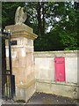
Eagle guarding postbox
This postbox at the entrance to Balcraig House has its slot blocked and is no longer in use. It is unusual in Scotland to see such a postbox with the 'EIIR' symbol. Most carry simply 'ER' instead, following the blowing up of several by persons protesting that Scotland (and hence the United Kingdom) never had a previous Elizabeth monarch, so the new Queen was 'second to none in Scotland'.
Image: © James Allan
Taken: 6 Sep 2010
0.03 miles
3
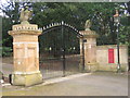
Entrance to Balcraig
Handsome Eagles.
Image: © Ross Mathieson
Taken: 6 Apr 2007
0.06 miles
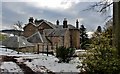
4
Sheep grazing on stubble
The late afternoon sun picks out these sheep working methodically across the stubble field.
Image: © Lis Burke
Taken: 20 Feb 2010
0.07 miles
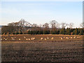
5
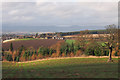
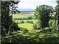
Field north of Balcraig
Looking across pasture towards Scone. The large farm in the distance is (I think) Balgarvie.
Image: © Rob Burke
Taken: 2 Jan 2014
0.08 miles
6
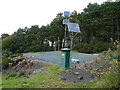
Balcraig reservoir
Solar panels power equipment at Scottish Water's Balcraig reservoir.
Image: © James Allan
Taken: 6 Sep 2010
0.14 miles
7
McDuffs Folly
Monument marked on bottom right hand corner of grid square
Image: © Karen Vernon
Taken: 31 Jul 2005
0.15 miles
8
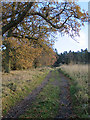
Track to McDuff's Folly
I did intend to walk up to the monument, or folly, but was defeated by a combination of gathering clouds and an absence of places to leave the car safely. The track also leads to a reservoir and a Scottish Water sign on the gate warns that 24-hour access is required.
Image: © Anne Burgess
Taken: 26 Nov 2017
0.17 miles
9
Lynedoch, 17th hole, Stormont
The short downhill seventeenth hole on the Lynedoch Course at Murrayshall, from tee to green.
Image: © Scott Cormie
Taken: 26 Jul 2017
0.19 miles
10
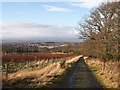
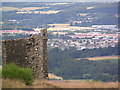
Track down from Balcraig Reservoir
This track provides access to Image, and from there a path climbs to McDuff's Monument higher up the hill. The large village of Scone can be seen in the distance.
Image: © Rob Burke
Taken: 2 Jan 2014
0.21 miles