IMAGES TAKEN NEAR TO
PERTH, PH2 7LQ
Introduction
This page details the photographs taken nearby to PH2 7LQ by members of the Geograph project.
The Geograph project started in 2005 with the aim of publishing, organising and preserving representative images for every square kilometre of Great Britain, Ireland and the Isle of Man.

There are currently over 7.5m images from over14,400 individuals and you can help contribute to the project by visiting https://www.geograph.org.uk
Image Map
Images are licensed for reuse under creativecommons.org/licenses/by-sa/2.0
Notes
- Clicking on the map will re-center to the selected point.
- The higher the marker number, the further away the image location is from the centre of the postcode.
Image Listing (10 Images Found)
Images are licensed for reuse under creativecommons.org/licenses/by-sa/2.0
Image
Details
Distance
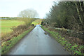
4
Craignorth corner
Blind bend on a yellow road
Image: © James Allan
Taken: 20 Mar 2006
0.13 miles
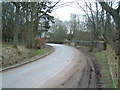
5
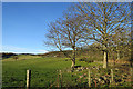
Ruins with Trees
The trees have sprung among the ruins of what is shown on the mid-Victorian Ordnance Survey map as a small house or other building.
Image: © Anne Burgess
Taken: 26 Nov 2017
0.14 miles
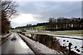
6
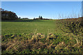
Looking towards Broompark
The buildings at Broompark are in the shade of the trees in the middle distance.
Image: © Anne Burgess
Taken: 26 Nov 2017
0.19 miles
7
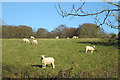
Ewes Looking at Me
Unusually, the sheep have not turned tail and fled, but are standing their ground and taking a good look at the interloper.
Image: © Anne Burgess
Taken: 26 Nov 2017
0.21 miles
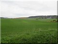
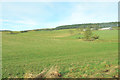
8
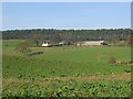
Commonbank
Perthshire farm hiding from the north wind below a substantial shelterbelt. The land to the north of the trees is quite high and wild. Below, good arable land. Looking north.
Image: © Richard Webb
Taken: 20 Nov 2005
0.23 miles
10
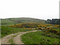
Track, Balthayock
With Balthayock Hill in the background.
Image: © Richard Webb
Taken: 15 May 2022
0.25 miles