IMAGES TAKEN NEAR TO
Bonhard Road, PERTH, PH2 6QB
Introduction
This page details the photographs taken nearby to Bonhard Road, PH2 6QB by members of the Geograph project.
The Geograph project started in 2005 with the aim of publishing, organising and preserving representative images for every square kilometre of Great Britain, Ireland and the Isle of Man.

There are currently over 7.5m images from over14,400 individuals and you can help contribute to the project by visiting https://www.geograph.org.uk
Image Map (Loading...)


Getting Data...Please wait
Leaflet Map data © OpenStreetMap
Images are licensed for reuse under creativecommons.org/licenses/by-sa/2.0
Notes
- Clicking on the map will re-center to the selected point.
- The higher the marker number, the further away the image location is from the centre of the postcode.
Image Listing (11 Images Found)
Images are licensed for reuse under creativecommons.org/licenses/by-sa/2.0
Image
Details
Distance
1
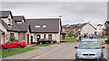
Hutchison Drive, Scone
Recently constructed houses, part of the Balgarvie development. Note the construction yard just visible in the distance on the right of the picture.
Image: © Rob Burke
Taken: 1 Jun 2013
0.11 miles
2
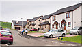
Coronation Avenue, Scone
Newly constructed houses on the eastern edge of Scone.
Image: © Rob Burke
Taken: 1 Jun 2013
0.15 miles
3
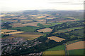
East side of Scone from the air
Taken from a hot air balloon above Gannochy, Perth. The woodland is in an area known as Nether Balgarvie.
Image: © Mike Pennington
Taken: 14 Aug 2013
0.17 miles
4
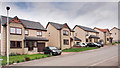
Hutchison Drive, Scone
Newly constructed houses, part of the Balgarvie development.
Image: © Rob Burke
Taken: 1 Jun 2013
0.18 miles
5
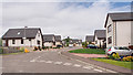
David Douglas Avenue
David Douglas Avenue is a long road with many branches. It starts at the north-eastern end of Scone and runs along the eastern edge of the village to this point. It was created by the first phase of the Balgarvie development.
Why do developers use the one name for multiple roads? There are few signs giving the house numbers, and the absence of street names makes it very hard to find addresses. I get lost every time.
Image: © Rob Burke
Taken: 1 Jun 2013
0.20 miles
6
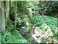
Annaty burn in Scone Den
Stream flowing down from the western end of the Sidlaw Hills to join the Tay near Perth.
Image: © James Allan
Taken: 14 Jul 2008
0.20 miles
7
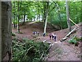
In Scone Den
Walkers crossing a footbridge over the Annety burn.
Image: © James Allan
Taken: 6 Sep 2010
0.20 miles
8
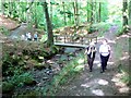
Footbridge over the Annety
Wooden bridge carrying a footpath across the waters of the Annety Burn.
Image: © James Allan
Taken: 14 Jul 2008
0.21 miles
9
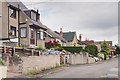
Myrtle Road, Scone
A street of houses with varying designs and (apparently) ages.
Image: © Rob Burke
Taken: 1 Jun 2013
0.22 miles
10
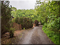
Road, Den of Scone
This is a private road serving houses at Den of Scone. It is also part of a footpath from the southern end of Scone to Bonhard.
Image: © Rob Burke
Taken: 1 Jun 2013
0.23 miles