IMAGES TAKEN NEAR TO
Kinrossie, PERTH, PH2 6HW
Introduction
This page details the photographs taken nearby to PH2 6HW by members of the Geograph project.
The Geograph project started in 2005 with the aim of publishing, organising and preserving representative images for every square kilometre of Great Britain, Ireland and the Isle of Man.

There are currently over 7.5m images from over14,400 individuals and you can help contribute to the project by visiting https://www.geograph.org.uk
Image Map
Images are licensed for reuse under creativecommons.org/licenses/by-sa/2.0
Notes
- Clicking on the map will re-center to the selected point.
- The higher the marker number, the further away the image location is from the centre of the postcode.
Image Listing (6 Images Found)
Images are licensed for reuse under creativecommons.org/licenses/by-sa/2.0
Image
Details
Distance
1
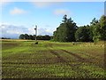
Emerging crop, Thorngreen
Winter cereals.
Image: © Richard Webb
Taken: 8 Oct 2013
0.07 miles
2
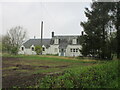
Thorngreen from the roadside
White-washed house at Thorngreen, viewed from the road to the south-east.
Image: © Scott Cormie
Taken: 1 May 2022
0.10 miles
3
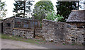
Abandoned Kennels
Adjacent to Thorngreen
Image: © Glen Breaden
Taken: 18 Apr 2011
0.10 miles
4
Stripwood, Clockmaden
A long strip, either side of the road.
Image: © Richard Webb
Taken: 8 Oct 2013
0.21 miles
5
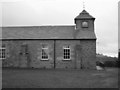
Kinrossie Town Hall
Built in 1843 as the Free Church (following the 'disruption' of the Church of Scotland) this building now serves as Kinrossie Town Hall
Image: © James Allan
Taken: 7 Feb 2006
0.23 miles
6
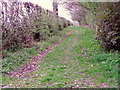
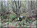
Track near Kinrossie
The track runs beside woodland and reaches another minor road at Thorngreen Cottage.
Image: © Maigheach-gheal
Taken: 15 Apr 2011
0.25 miles