IMAGES TAKEN NEAR TO
Burnside Road, PERTH, PH2 6HD
Introduction
This page details the photographs taken nearby to Burnside Road, PH2 6HD by members of the Geograph project.
The Geograph project started in 2005 with the aim of publishing, organising and preserving representative images for every square kilometre of Great Britain, Ireland and the Isle of Man.

There are currently over 7.5m images from over14,400 individuals and you can help contribute to the project by visiting https://www.geograph.org.uk
Image Map
Images are licensed for reuse under creativecommons.org/licenses/by-sa/2.0
Notes
- Clicking on the map will re-center to the selected point.
- The higher the marker number, the further away the image location is from the centre of the postcode.
Image Listing (5 Images Found)
Images are licensed for reuse under creativecommons.org/licenses/by-sa/2.0
Image
Details
Distance
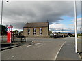
1

Balbeggie from the air
Taken from a hot air balloon just south of Scone.
Image: © Mike Pennington
Taken: 14 Aug 2013
0.20 miles
2
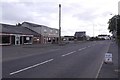
Outside the shop, Balbeggie
The A94 in Balbeggie.
Image: © Richard Webb
Taken: 29 Sep 2018
0.21 miles
4
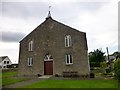
Balbeggie And Collace United Free Church Of Scotland
This church built in 1832.
Image: © Rude Health
Taken: 8 Aug 2014
0.21 miles
5
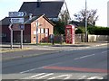
Telephone box, Balbeggie
A K6 type telephone box beside the A94.
Image: © Maigheach-gheal
Taken: 3 Oct 2009
0.22 miles