IMAGES TAKEN NEAR TO
The Old Dairy, PERTH, PH2 6FB
Introduction
This page details the photographs taken nearby to The Old Dairy, PH2 6FB by members of the Geograph project.
The Geograph project started in 2005 with the aim of publishing, organising and preserving representative images for every square kilometre of Great Britain, Ireland and the Isle of Man.

There are currently over 7.5m images from over14,400 individuals and you can help contribute to the project by visiting https://www.geograph.org.uk
Image Map
Images are licensed for reuse under creativecommons.org/licenses/by-sa/2.0
Notes
- Clicking on the map will re-center to the selected point.
- The higher the marker number, the further away the image location is from the centre of the postcode.
Image Listing (26 Images Found)
Images are licensed for reuse under creativecommons.org/licenses/by-sa/2.0
Image
Details
Distance
1
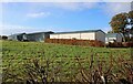
Business Park, Meikleour estate
The Old Dairy at Meikleour was converted into a business park in 2011. There are 4 offices/light workshops and 15 industrial units.
Image: © Richard Sutcliffe
Taken: 31 Oct 2023
0.03 miles
2
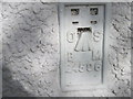
Ordnance Survey Flush Bracket G4506
This can be found on the wall of the Old Smithy House.
For more detail see : http://www.bench-marks.org.uk/bm17895
Image: © Peter Wood
Taken: 29 Sep 2012
0.08 miles
3
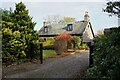
Parkview, Meikleour
Cottage dating from 1820-40 in Meikleour. It is category C listed https://portal.historicenvironment.scot/designation/LB4418.
Image: © Richard Sutcliffe
Taken: 31 Oct 2023
0.08 miles
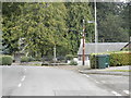
4
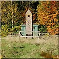
The Tron, Meikleour
A Category B listed https://portal.historicenvironment.scot/designation/LB4447 rusticated obelisk with hole near the top in a field, just to the west of the A984 road in Meikleour. The remains of a jougs - a hinged iron collar chained to the stone, which was used in medieval Scotland as an instrument of punishment, is still present. The spike on the top of the stone has a weather vane at the top (not visible in photograph). The green structure behind is an electricity substation.
Image: © Richard Sutcliffe
Taken: 31 Oct 2023
0.08 miles
5

Meikleour Village hall and Institute
Arts and Crafts village hall and institute dating from 1930. It is category C listed https://portal.historicenvironment.scot/designation/LB51922.
Image: © Richard Sutcliffe
Taken: 31 Oct 2023
0.09 miles
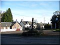
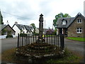
8
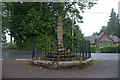
Mercat Cross, Meikleour
Category A listed https://portal.historicenvironment.scot/designation/LB4446 cross in Meikleour. It is dated 1698. It was badly damaged in 1964 and has been rebuilt (See Canmore for images https://canmore.org.uk/site/28550/meikleour-mercat-cross ) but it is currently in the Buildings at Risk Register https://www.buildingsatrisk.org.uk/details/1158330.
Image: © Richard Sutcliffe
Taken: 31 Oct 2023
0.10 miles
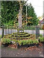
10
Mercat Cross, Meikleour
The cross dates from the 17th century.
Image: © Mike Pennington
Taken: 11 Jul 2011
0.10 miles