IMAGES TAKEN NEAR TO
Balbeggie, PERTH, PH2 6ET
Introduction
This page details the photographs taken nearby to PH2 6ET by members of the Geograph project.
The Geograph project started in 2005 with the aim of publishing, organising and preserving representative images for every square kilometre of Great Britain, Ireland and the Isle of Man.

There are currently over 7.5m images from over14,400 individuals and you can help contribute to the project by visiting https://www.geograph.org.uk
Image Map
Images are licensed for reuse under creativecommons.org/licenses/by-sa/2.0
Notes
- Clicking on the map will re-center to the selected point.
- The higher the marker number, the further away the image location is from the centre of the postcode.
Image Listing (6 Images Found)
Images are licensed for reuse under creativecommons.org/licenses/by-sa/2.0
Image
Details
Distance
1
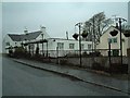
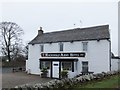
The MacDonald Arms Hotel
Balbeggie village's pub, restaurant and hotel
Image: © James Allan
Taken: 10 Jan 2006
0.19 miles
2
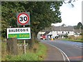
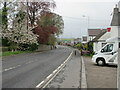
Balbeggie city limits
30mph sign on the A94 and a view towards the Macdonald Arms where I am about to turn off for quieter roads.
Image: © Richard Webb
Taken: 8 Oct 2013
0.20 miles
4
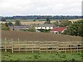
Edge of Balbeggie
Looking over what appears to be emerging oilseed rape towards part of the village.
Image: © Richard Webb
Taken: 8 Oct 2013
0.23 miles
6
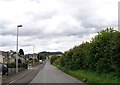
A94 at Balbeggie
The A94 heading into Balbeggie from the south.
Image: © Scott Cormie
Taken: 1 May 2022
0.25 miles