IMAGES TAKEN NEAR TO
Meikleour, PERTH, PH2 6EH
Introduction
This page details the photographs taken nearby to PH2 6EH by members of the Geograph project.
The Geograph project started in 2005 with the aim of publishing, organising and preserving representative images for every square kilometre of Great Britain, Ireland and the Isle of Man.

There are currently over 7.5m images from over14,400 individuals and you can help contribute to the project by visiting https://www.geograph.org.uk
Image Map
Images are licensed for reuse under creativecommons.org/licenses/by-sa/2.0
Notes
- Clicking on the map will re-center to the selected point.
- The higher the marker number, the further away the image location is from the centre of the postcode.
Image Listing (8 Images Found)
Images are licensed for reuse under creativecommons.org/licenses/by-sa/2.0
Image
Details
Distance

2

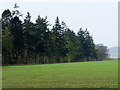
Beeches, Lethendy
Autumnal beeches in a field boundary.
Image: © Richard Webb
Taken: 30 Oct 2016
0.13 miles
3
Arable field near Lethendy
The young cereal crop is growing well.
Image: © Maigheach-gheal
Taken: 10 Apr 2011
0.14 miles
4
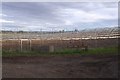
Polytunnel frames, Essendy
The Blairgowrie berry fields.
Image: © Richard Webb
Taken: 28 Oct 2017
0.16 miles
5
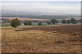
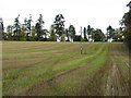
Stubble, Mains of Pittendriech
Eight years on from Image
Image: © Richard Webb
Taken: 30 Oct 2016
0.18 miles
6
Essendy
Patterns in the stubble, from new growth. By Essendy House.
Image: © Richard Webb
Taken: 29 Oct 2006
0.20 miles
7
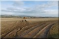
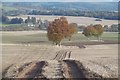
Stubble near Mains of Pittendriech
The mud was drying out during a dry spell. There is a view towards the Highland Boundary Fault.
Image: © Richard Webb
Taken: 30 Oct 2016
0.21 miles