IMAGES TAKEN NEAR TO
Meikleour, PERTH, PH2 6EG
Introduction
This page details the photographs taken nearby to PH2 6EG by members of the Geograph project.
The Geograph project started in 2005 with the aim of publishing, organising and preserving representative images for every square kilometre of Great Britain, Ireland and the Isle of Man.

There are currently over 7.5m images from over14,400 individuals and you can help contribute to the project by visiting https://www.geograph.org.uk
Image Map
Images are licensed for reuse under creativecommons.org/licenses/by-sa/2.0
Notes
- Clicking on the map will re-center to the selected point.
- The higher the marker number, the further away the image location is from the centre of the postcode.
Image Listing (6 Images Found)
Images are licensed for reuse under creativecommons.org/licenses/by-sa/2.0
Image
Details
Distance
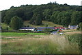
2
White cottage
White cottage at the Kirkton of Lethendy.
Image: © Scott Cormie
Taken: 6 Jun 2021
0.04 miles
3
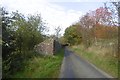
Partly ruined wall, Kirkton of Lethendy
A wall accompanies the road as it climbs out of Kirkton of Lethendy.
Image: © Richard Webb
Taken: 30 Oct 2016
0.06 miles
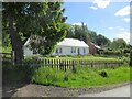
4

Ruined kirk, Kirkton of Lethendy
The ruined kirk is said to date from 1574 and there are a number of 17th and 18th century gravestones within the burial ground.
Image: © Maigheach-gheal
Taken: 10 Apr 2011
0.09 miles
5
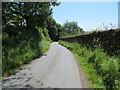
Minor road leading to Kirton of Lethendy
Looking south-eastward.
Image: © Peter Wood
Taken: 28 Jun 2019
0.13 miles
6
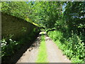
Enclosed track leading to Mains of Gourdie
Looking north-westward.
Image: © Peter Wood
Taken: 28 Jun 2019
0.22 miles