IMAGES TAKEN NEAR TO
PERTH, PH2 6DR
Introduction
This page details the photographs taken nearby to PH2 6DR by members of the Geograph project.
The Geograph project started in 2005 with the aim of publishing, organising and preserving representative images for every square kilometre of Great Britain, Ireland and the Isle of Man.

There are currently over 7.5m images from over14,400 individuals and you can help contribute to the project by visiting https://www.geograph.org.uk
Image Map
Images are licensed for reuse under creativecommons.org/licenses/by-sa/2.0
Notes
- Clicking on the map will re-center to the selected point.
- The higher the marker number, the further away the image location is from the centre of the postcode.
Image Listing (4 Images Found)
Images are licensed for reuse under creativecommons.org/licenses/by-sa/2.0
Image
Details
Distance
2
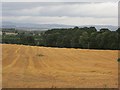
Harvested field near Mains of Stobhall
Straw awaits the baler.
Image: © Richard Webb
Taken: 16 Sep 2012
0.13 miles
3
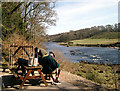
River Tay at Innernyte
Salmon anglers preparing to fish the Taymount beat.
Image: © Andy Stephenson
Taken: 4 Apr 2003
0.22 miles
4
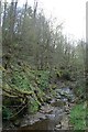
Tributary of the River Tay near Broadgreen
This was not easy walking and would not have been in the 17th century when Gilbert West was pursued by Royalist dragoons after attending a conventicle (open air service) at nearby Broadgreen. (See Image]) 'Gibbie' was shot and his body found days later in this or one of the other gullies in the vicinity. The area became known as 'Gibbie's Den'.
Image: © Becky Williamson
Taken: 11 Apr 2012
0.23 miles