IMAGES TAKEN NEAR TO
PERTH, PH2 6BN
Introduction
This page details the photographs taken nearby to PH2 6BN by members of the Geograph project.
The Geograph project started in 2005 with the aim of publishing, organising and preserving representative images for every square kilometre of Great Britain, Ireland and the Isle of Man.

There are currently over 7.5m images from over14,400 individuals and you can help contribute to the project by visiting https://www.geograph.org.uk
Image Map
Images are licensed for reuse under creativecommons.org/licenses/by-sa/2.0
Notes
- Clicking on the map will re-center to the selected point.
- The higher the marker number, the further away the image location is from the centre of the postcode.
Image Listing (6 Images Found)
Images are licensed for reuse under creativecommons.org/licenses/by-sa/2.0
Image
Details
Distance
1
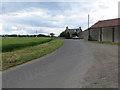
Minor road at Cambusmichael
Looking westward.
Image: © Peter Wood
Taken: 22 Jun 2019
0.02 miles
2
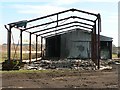
Destroyed barn
This barn seems to have been destroyed by a fire.
Image: © Rob Burke
Taken: 4 Feb 2006
0.04 miles
3
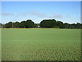
Green field near Cambusmichael
Looking north-west over a newly planted field near Cambusmichael.
Image: © Scott Cormie
Taken: 18 Sep 2021
0.12 miles
4
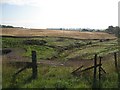
Cambusmichael Burn
A small burn running just below the general ground level as it starts to cut down to the Tay.
Image: © Richard Webb
Taken: 8 Aug 2009
0.20 miles
5
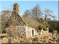
Cambusmichael Church
This ruined church is close to the Tay, but well above it. Seen from the west end. I don't know when it was abandoned, but a sketch from 1911 shows it in much the same state as today. See http://www.stormontfield.co.uk/html/cambusmichael.html .
Image: © Rob Burke
Taken: 4 Feb 2006
0.22 miles
6
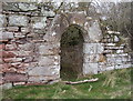
The Old Doorway, Cambusmichael Ruin
The area of Cambusmichael derives its name, in part, from Gaelic, "Cambus", which signifies "a small low plain", and the church, Michael.
Image: © perth pathfinders
Taken: 18 Jan 2002
0.22 miles