IMAGES TAKEN NEAR TO
GRANTOWN-ON-SPEY, PH26 3PN
Introduction
This page details the photographs taken nearby to PH26 3PN by members of the Geograph project.
The Geograph project started in 2005 with the aim of publishing, organising and preserving representative images for every square kilometre of Great Britain, Ireland and the Isle of Man.

There are currently over 7.5m images from over14,400 individuals and you can help contribute to the project by visiting https://www.geograph.org.uk
Image Map
Images are licensed for reuse under creativecommons.org/licenses/by-sa/2.0
Notes
- Clicking on the map will re-center to the selected point.
- The higher the marker number, the further away the image location is from the centre of the postcode.
Image Listing (6 Images Found)
Images are licensed for reuse under creativecommons.org/licenses/by-sa/2.0
Image
Details
Distance
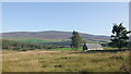
1
Wester Lettock
A hilltop farm with highland cattle enjoying the rough grazing.
Image: © Andrew Wood
Taken: 3 Jul 2009
0.01 miles
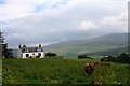
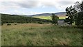
2
Cattle, Strathspey
View past the Highland cattle towards the Cromdale Hills.
Image: © Richard Webb
Taken: 4 Aug 2014
0.08 miles
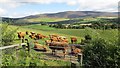
3
Birch woods, Wester Lettoch
Farmland reverting to birchwood.
Image: © Richard Webb
Taken: 26 Aug 2021
0.10 miles

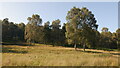
5
East Lettoch
Grass field amongst the woodlands of Strathspey.
Image: © Richard Webb
Taken: 4 Aug 2014
0.18 miles