IMAGES TAKEN NEAR TO
Dulnain Bridge, GRANTOWN-ON-SPEY, PH26 3NU
Introduction
This page details the photographs taken nearby to PH26 3NU by members of the Geograph project.
The Geograph project started in 2005 with the aim of publishing, organising and preserving representative images for every square kilometre of Great Britain, Ireland and the Isle of Man.

There are currently over 7.5m images from over14,400 individuals and you can help contribute to the project by visiting https://www.geograph.org.uk
Image Map (Loading...)


Getting Data...Please wait
Leaflet Map data © OpenStreetMap
Images are licensed for reuse under creativecommons.org/licenses/by-sa/2.0
Notes
- Clicking on the map will re-center to the selected point.
- The higher the marker number, the further away the image location is from the centre of the postcode.
Image Listing (4 Images Found)
Images are licensed for reuse under creativecommons.org/licenses/by-sa/2.0
Image
Details
Distance
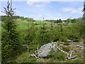
2
Dead pines, Laggan
Standing dead timber on the edge of Gaich Wood.
Image: © Richard Webb
Taken: 19 May 2023
0.22 miles
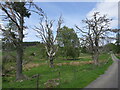
3
The road to Easter Laggan
Easter Laggan is a farm close to Dulnain Bridge. This access road for it leaves the A95/A938 junction east of that village and passes through woodland before reaching fields as the Scots pine on the left side of the image is passed.
Image: © Trevor Littlewood
Taken: 26 Oct 2006
0.23 miles