IMAGES TAKEN NEAR TO
GRANTOWN-ON-SPEY, PH26 3NT
Introduction
This page details the photographs taken nearby to PH26 3NT by members of the Geograph project.
The Geograph project started in 2005 with the aim of publishing, organising and preserving representative images for every square kilometre of Great Britain, Ireland and the Isle of Man.

There are currently over 7.5m images from over14,400 individuals and you can help contribute to the project by visiting https://www.geograph.org.uk
Image Map
Images are licensed for reuse under creativecommons.org/licenses/by-sa/2.0
Notes
- Clicking on the map will re-center to the selected point.
- The higher the marker number, the further away the image location is from the centre of the postcode.
Image Listing (10 Images Found)
Images are licensed for reuse under creativecommons.org/licenses/by-sa/2.0
Image
Details
Distance
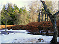
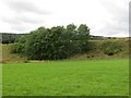
3
Birch Woods near Wester Craggan
There is a large area of birch woodland by the road in Glenbeg
Image: © Dorothy Carse
Taken: 18 May 2008
0.20 miles
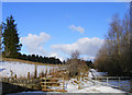
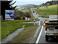
5
Railway embankment
It is planned to reopen the railway here soon, linking Grantown with Aviemore.
Image: © Richard Webb
Taken: 4 Aug 2014
0.20 miles
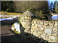
6
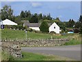
Craggan Mill Restaurant
It was closed at this time.
Image: © Richard Webb
Taken: 13 Sep 2014
0.20 miles

9
Entrance road to Craggan Outdoor Centre
Image: © Steven Brown
Taken: 16 Jul 2022
0.24 miles
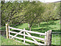
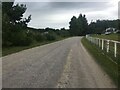
10
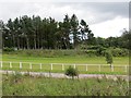
Craggan Outdoors
Near the entrance to Craggan Outdoors, a golf course and provider of other activities.
Image: © Richard Webb
Taken: 4 Aug 2014
0.25 miles