IMAGES TAKEN NEAR TO
GRANTOWN-ON-SPEY, PH26 3NH
Introduction
This page details the photographs taken nearby to PH26 3NH by members of the Geograph project.
The Geograph project started in 2005 with the aim of publishing, organising and preserving representative images for every square kilometre of Great Britain, Ireland and the Isle of Man.

There are currently over 7.5m images from over14,400 individuals and you can help contribute to the project by visiting https://www.geograph.org.uk
Image Map
Images are licensed for reuse under creativecommons.org/licenses/by-sa/2.0
Notes
- Clicking on the map will re-center to the selected point.
- The higher the marker number, the further away the image location is from the centre of the postcode.
Image Listing (11 Images Found)
Images are licensed for reuse under creativecommons.org/licenses/by-sa/2.0
Image
Details
Distance
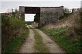
1
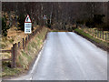
Balliefurth Farm Beside the Speyside Way
The Speyside Way utilises the former railway trackbed from Nethy Bridge up to Grantown-on-Spey. At one time, Balliefurth Farm was one of only two farms in Scotland to have its one railway halt.
Image: © Peter Trimming
Taken: 22 Apr 2014
0.07 miles
2
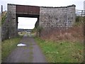
Bridge over dismantled railway line
The bridge carried a track from Balliefurth farm across the railway line that was dismantled in the 1960s. The dismantled line now forms part of the Speyside Way footpath.
Image: © Roy Turnbull
Taken: 15 Dec 2006
0.10 miles
3
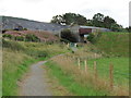
The Speyside Way near Balliefurth Farm
The path has been redirected to avoid the farmyard.
Image: © Dave Kelly
Taken: 12 Sep 2017
0.10 miles
4
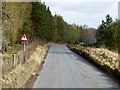
Speyside Way
The Speyside Way utilises the former railway trackbed from Nethy Bridge up to Grantown-on-Spey.
Image: © Peter Trimming
Taken: 22 Apr 2014
0.11 miles
5
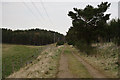
Speyside Way
The Speyside Way utilises the former railway trackbed from Nethy Bridge up to Grantown-on-Spey.
Image: © Peter Trimming
Taken: 22 Apr 2014
0.13 miles
6
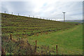
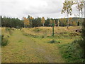
Embankment at Balliefurth Farm
At Balliefurth the Speyside Way is briefly diverted off the former Strathspey Railway trackbed to avoid going through the farmyard. This embankment leads up to a bridge over the former railway that gives access to fields to the north of the trackbed. Interesting to see the effects of freezing and thawing in the little solifluction terraces that have developed along the slope of the embankment.
Image: © Anne Burgess
Taken: 5 Nov 2018
0.13 miles
7
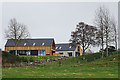
New House
The all-glass wall must have a fine view across the River Spey flood plain, besides enjoying the afternoon sunshine.
Image: © Anne Burgess
Taken: 5 Nov 2018
0.19 miles