IMAGES TAKEN NEAR TO
GRANTOWN-ON-SPEY, PH26 3LG
Introduction
This page details the photographs taken nearby to PH26 3LG by members of the Geograph project.
The Geograph project started in 2005 with the aim of publishing, organising and preserving representative images for every square kilometre of Great Britain, Ireland and the Isle of Man.

There are currently over 7.5m images from over14,400 individuals and you can help contribute to the project by visiting https://www.geograph.org.uk
Image Map
Images are licensed for reuse under creativecommons.org/licenses/by-sa/2.0
Notes
- Clicking on the map will re-center to the selected point.
- The higher the marker number, the further away the image location is from the centre of the postcode.
Image Listing (8 Images Found)
Images are licensed for reuse under creativecommons.org/licenses/by-sa/2.0
Image
Details
Distance
1
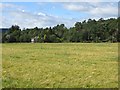
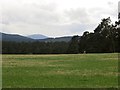
Barley, Drumdunan
A field in a mostly wooded area near Grantown.
Image: © Richard Webb
Taken: 4 Aug 2014
0.12 miles
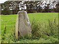
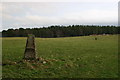
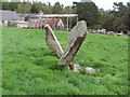
3
Standing stone, Upper Port
One of several, set in a field beside Anagach Wood.
Image: © Richard Webb
Taken: 4 May 2014
0.16 miles
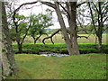
4
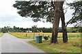
Access road to Drumdunan
Off the B9102 at Upper Port.
Image: © Alan Reid
Taken: 25 Aug 2024
0.19 miles
6
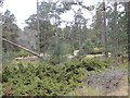
Anagach Wood
Juniper and Scots pine wood set on a spectacular kame and kettle landscape.
Image: © Richard Webb
Taken: 4 May 2014
0.21 miles