IMAGES TAKEN NEAR TO
NETHY BRIDGE, PH25 3EE
Introduction
This page details the photographs taken nearby to PH25 3EE by members of the Geograph project.
The Geograph project started in 2005 with the aim of publishing, organising and preserving representative images for every square kilometre of Great Britain, Ireland and the Isle of Man.

There are currently over 7.5m images from over14,400 individuals and you can help contribute to the project by visiting https://www.geograph.org.uk
Image Map
Images are licensed for reuse under creativecommons.org/licenses/by-sa/2.0
Notes
- Clicking on the map will re-center to the selected point.
- The higher the marker number, the further away the image location is from the centre of the postcode.
Image Listing (8 Images Found)
Images are licensed for reuse under creativecommons.org/licenses/by-sa/2.0
Image
Details
Distance
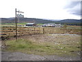
1
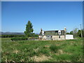
Ellon Cottage, Dorback Estate
A renovated traditional cottage on the Dorback Estate.
Image: © Alan O'Dowd
Taken: 3 Jun 2023
0.00 miles
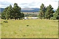
2
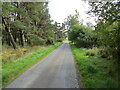
Tree-lined minor road approaching Muckerach
Looking south-eastward.
Image: © Peter Wood
Taken: 23 Sep 2020
0.15 miles
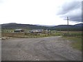
4
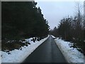
Track near Muckerach
On the Dorback Estate near Nethy Bridge.
Image: © Alan O'Dowd
Taken: 8 Jun 2023
0.20 miles
8
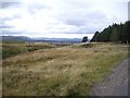
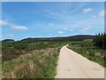
Looking down a burn valley
Past Muckerach.
Image: © Stanley Howe
Taken: 9 Oct 2009
0.24 miles