IMAGES TAKEN NEAR TO
NETHY BRIDGE, PH25 3DW
Introduction
This page details the photographs taken nearby to PH25 3DW by members of the Geograph project.
The Geograph project started in 2005 with the aim of publishing, organising and preserving representative images for every square kilometre of Great Britain, Ireland and the Isle of Man.

There are currently over 7.5m images from over14,400 individuals and you can help contribute to the project by visiting https://www.geograph.org.uk
Image Map
Images are licensed for reuse under creativecommons.org/licenses/by-sa/2.0
Notes
- Clicking on the map will re-center to the selected point.
- The higher the marker number, the further away the image location is from the centre of the postcode.
Image Listing (114 Images Found)
Images are licensed for reuse under creativecommons.org/licenses/by-sa/2.0
Image
Details
Distance
1
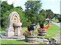
A Drinking Fountain at Nethy Bridge
This is situated on Dell Road,opposite the Post Office.
Image: © Ann Harrison
Taken: 29 Jul 2008
0.03 miles
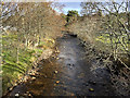
2
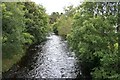
River Nethy
Looking upstream from the bridge.
Image: © Mick Garratt
Taken: 7 Aug 2007
0.03 miles
3
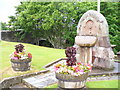
"Drink Hearty"
Old stone well at Nethy Bridge, with the bridge itself in the background.
http://www.nethybridge.com/
Image: © Colin Smith
Taken: 8 Jul 2008
0.03 miles
4
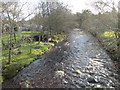
River Nethy
The River Nethy (Scottish Gaelic: Neithich / Abhainn Neithich) is a tributary of the River Spey in northeast Scotland. It rises as the Garbh Allt between Cairn Gorm and A' Chòinneach on the northern slopes of the Cairngorms and flows northwards through Strath Nethy and into Abernethy Forest. Passing through the village of Nethy Bridge which takes its name from the river and the bridge which carries the B970 road across it. The Nethy then turns northwestward before entering the Spey at Broomhill. This view is looking upstream from the bridge.
Image: © David Dixon
Taken: 3 Apr 2017
0.04 miles
5
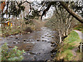
River Nethy at Nethy Bridge
The River Nethy (Scottish Gaelic: Neithich / Abhainn Neithich) is a tributary of the River Spey in northeast Scotland. It rises as the Garbh Allt between Cairn Gorm and A' Chòinneach on the northern slopes of the Cairngorms and flows northwards through Strath Nethy and into Abernethy Forest. Passing through the village of Nethy Bridge which takes its name from the river and the bridge which carries the B970 road across it. The Nethy then turns northwestward before entering the Spey at Broomhill. This view is looking upstream from the path near the bridge.
Image: © David Dixon
Taken: 3 Apr 2017
0.04 miles
6
River Nethy
Looking upstream from the bridge.
Image: © Jennifer Jones
Taken: 30 Jan 2013
0.04 miles
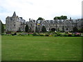
8
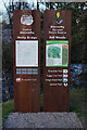
Information Boards in Nethy Bridge
Located in the centre of the village, overlooking the River Nethy. The boards give information on local walks, both in the village and in the Abernethy Forest.
Image: © Peter Trimming
Taken: 19 Apr 2014
0.04 miles
9
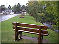
Bench by River Nethy
At start of Riverside Path.
Image: © Stanley Howe
Taken: 9 Oct 2009
0.05 miles