IMAGES TAKEN NEAR TO
NETHY BRIDGE, PH25 3DL
Introduction
This page details the photographs taken nearby to PH25 3DL by members of the Geograph project.
The Geograph project started in 2005 with the aim of publishing, organising and preserving representative images for every square kilometre of Great Britain, Ireland and the Isle of Man.

There are currently over 7.5m images from over14,400 individuals and you can help contribute to the project by visiting https://www.geograph.org.uk
Image Map
Images are licensed for reuse under creativecommons.org/licenses/by-sa/2.0
Notes
- Clicking on the map will re-center to the selected point.
- The higher the marker number, the further away the image location is from the centre of the postcode.
Image Listing (9 Images Found)
Images are licensed for reuse under creativecommons.org/licenses/by-sa/2.0
Image
Details
Distance

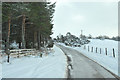
2
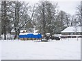
Dell of Abernethy
A strip of farmland between the river and the forest.
Image: © Richard Webb
Taken: 4 Mar 2006
0.09 miles
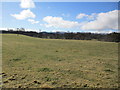
3

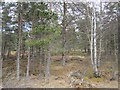
Dell Road, Nethybridge
Heading into Abernethy Forest.
Image: © Hugh Venables
Taken: 21 Jun 2012
0.17 miles
5
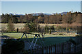
View From Nethy Bridge
View towards the Cairngorm Mountains, from the B&B.
Image: © Peter Trimming
Taken: 20 Apr 2014
0.21 miles
6
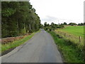
Lettoch Road, Nethy Bridge
Looking south-eastward.
Image: © Peter Wood
Taken: 23 Sep 2020
0.22 miles
8
Garlyne Moss
A wooded bit of peatland outside Nethy Bridge. It was sheltering cattle.
Image: © Richard Webb
Taken: 5 May 2013
0.24 miles
9
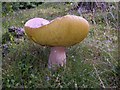
Cep (Boletus pinicola), an edible fungus
The undisturbed and unfertilised soils of Strathspey's woodlands provide a rich source of edible fungi like this cep. Of course, they also produce many poisonous species, so be sure you can tell the difference!
Image: © Roy Turnbull
Taken: 4 Sep 2006
0.24 miles