IMAGES TAKEN NEAR TO
CARRBRIDGE, PH23 3ND
Introduction
This page details the photographs taken nearby to PH23 3ND by members of the Geograph project.
The Geograph project started in 2005 with the aim of publishing, organising and preserving representative images for every square kilometre of Great Britain, Ireland and the Isle of Man.

There are currently over 7.5m images from over14,400 individuals and you can help contribute to the project by visiting https://www.geograph.org.uk
Image Map
Images are licensed for reuse under creativecommons.org/licenses/by-sa/2.0
Notes
- Clicking on the map will re-center to the selected point.
- The higher the marker number, the further away the image location is from the centre of the postcode.
Image Listing (8 Images Found)
Images are licensed for reuse under creativecommons.org/licenses/by-sa/2.0
Image
Details
Distance
4
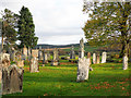
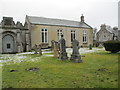
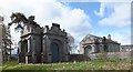
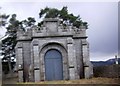
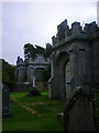
Gravestones at Duthil
The church building at Duthil is now the Clan Grant Centre. There are two mausolea in or adjacent to the graveyard, both at the eastern end of the building; the monuments in view are on the south side.
Image: © Trevor Littlewood
Taken: 26 Oct 2017
0.06 miles
6
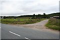
Easter Duthil Farm with Lochgorm Woods in the background.
Image: © Des Colhoun
Taken: 17 Sep 2006
0.19 miles
8
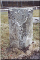
Old Milestone by the A938 at Duthill
Granite milestone by the A938, in parish of Duthil and Rothiemurchis (Inverness District), Duthil, on verge in front of wood. Now set back from road at entrance to Treetops, Woodlands.
Inscription once read:-
: (Inverness / 26½) : : (Grantown / 7½) :
Surveyed
Milestone Society National ID: HI_CBGS02
Image: © Milestone Society
Taken: Unknown
0.24 miles