IMAGES TAKEN NEAR TO
CARRBRIDGE, PH23 3AG
Introduction
This page details the photographs taken nearby to PH23 3AG by members of the Geograph project.
The Geograph project started in 2005 with the aim of publishing, organising and preserving representative images for every square kilometre of Great Britain, Ireland and the Isle of Man.

There are currently over 7.5m images from over14,400 individuals and you can help contribute to the project by visiting https://www.geograph.org.uk
Image Map
Images are licensed for reuse under creativecommons.org/licenses/by-sa/2.0
Notes
- Clicking on the map will re-center to the selected point.
- The higher the marker number, the further away the image location is from the centre of the postcode.
Image Listing (10 Images Found)
Images are licensed for reuse under creativecommons.org/licenses/by-sa/2.0
Image
Details
Distance
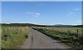
1
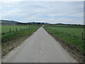
Road to Auchterblair
Fertile fields either side, in the Dulnain flood plain.
Image: © Jennifer Jones
Taken: 29 May 2013
0.02 miles
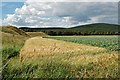
3
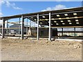
Steadings: ancient and modern
A new building with its predecessor remaining within. The roof of the old building was over the road.
Image: © Richard Webb
Taken: 4 Aug 2014
0.05 miles
4
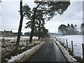
Minor road, Auchterblair
Running through mixed farmland.
Image: © Richard Webb
Taken: 4 Aug 2014
0.06 miles
6
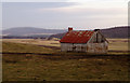
Derelict Cottage, Auchterblair
Old wooden cottage standing in rough grazing close to Auchterblair Farm.
Image: © Dorothy Carse
Taken: 31 Jan 2009
0.10 miles
7
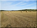
Field of stubble and pre-packed straw near to Auchterblair
Looking north-eastward.
Image: © Peter Wood
Taken: 20 Sep 2020
0.13 miles
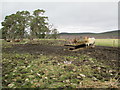
8
By Auchterblair
Edge of flood plain by Auchterblair
Image: © Jim Bain
Taken: 30 Jul 2006
0.14 miles
10
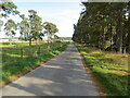
Minor road beside Carr Plantation
Looking south-eastward.
Image: © Peter Wood
Taken: 20 Sep 2020
0.23 miles