IMAGES TAKEN NEAR TO
Milton Park, AVIEMORE, PH22 1RS
Introduction
This page details the photographs taken nearby to Milton Park, PH22 1RS by members of the Geograph project.
The Geograph project started in 2005 with the aim of publishing, organising and preserving representative images for every square kilometre of Great Britain, Ireland and the Isle of Man.

There are currently over 7.5m images from over14,400 individuals and you can help contribute to the project by visiting https://www.geograph.org.uk
Image Map
Images are licensed for reuse under creativecommons.org/licenses/by-sa/2.0
Notes
- Clicking on the map will re-center to the selected point.
- The higher the marker number, the further away the image location is from the centre of the postcode.
Image Listing (37 Images Found)
Images are licensed for reuse under creativecommons.org/licenses/by-sa/2.0
Image
Details
Distance
4
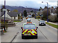
Threatening sky - Aviemore
The threat of torrential rain was made good shortly after.
The road on the left is the former A9 trunk route, now the B9152.
Image: © John Allan
Taken: 8 Sep 2016
0.07 miles
5
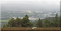
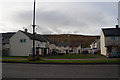
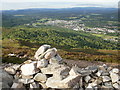
Aviemore
Will be interesting to compare this view from Beinn Ghuilbin with one in a few years' time, given the rate of urban sprawl here.
Amazingly some folk still call this a village!
Image: © Richard Webb
Taken: 27 Sep 2008
0.07 miles
6
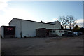
Aviemore Village Hall
Located just on Grampian Road at the north end of the village. Not the prettiest of buildings.
Image: © Phil Champion
Taken: 11 Oct 2011
0.07 miles
7
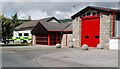
Aviemore Fire Station
Located next to a new medical centre in the northern part of Aviemore.
Image: © Mary and Angus Hogg
Taken: 21 Aug 2011
0.07 miles
8
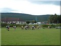
Aviemore public football pitch
Aviemore Thistle FC (yellow/black) take on local Rivals Carr-bridge FC (white/black) in the McCook Cup Final. Carr-bridge ran out eventual 4-2 winners.
In the background is the Health Centre and Fire Station (tower visible).
Image: © Alasdair MacNeill
Taken: 27 Jul 2007
0.08 miles
9
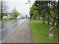
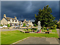
Milestone on Grampian Road, Aviemore
A milestone on Grampian Road in the town of Aviemore, in the Highlands of Scotland. This area lies within the Cairngorms National Park.
The road used to be part of the trunk A9, taking traffic through the town. The A9 now by-passes Aviemore and this road has been reclassified as the B9152. The road is on the route of the Speyside Way long distance path.
Image: © Malc McDonald
Taken: 23 Apr 2023
0.08 miles
10
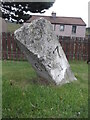
Old milestone
On the B9152 (old A9) at the north end of Aviemore near Morlich Court. In 2010 this granite stone was upright, in 2015 found leaning. The legend painted on the granite is CARRBRIDGE 6 on the left face, KINCRAIG 7 on the right with A9 on the bevel. There is a bench mark carved into the top edge.
Image: © Chris Minto
Taken: 21 May 2015
0.08 miles