IMAGES TAKEN NEAR TO
Croila Road, KINGUSSIE, PH21 1PB
Introduction
This page details the photographs taken nearby to Croila Road, PH21 1PB by members of the Geograph project.
The Geograph project started in 2005 with the aim of publishing, organising and preserving representative images for every square kilometre of Great Britain, Ireland and the Isle of Man.

There are currently over 7.5m images from over14,400 individuals and you can help contribute to the project by visiting https://www.geograph.org.uk
Image Map
Images are licensed for reuse under creativecommons.org/licenses/by-sa/2.0
Notes
- Clicking on the map will re-center to the selected point.
- The higher the marker number, the further away the image location is from the centre of the postcode.
Image Listing (51 Images Found)
Images are licensed for reuse under creativecommons.org/licenses/by-sa/2.0
Image
Details
Distance
4
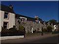
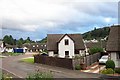
Low Houses
A row of terraced houses on the entrance into Kingussie
Image: © Graeme Smith
Taken: 11 Oct 2010
0.09 miles
5
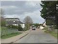
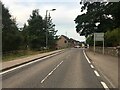
Dunbarry Road, Kingussie
Hillside road on the east side of the small town.
Image: © Gordon Hatton
Taken: 28 Apr 2022
0.09 miles
7
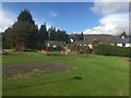
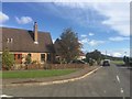
Playground, Kingussie
Off Dunbarry Terrace.
Image: © Richard Webb
Taken: 23 Sep 2019
0.11 miles
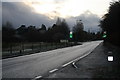
8
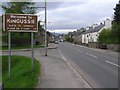
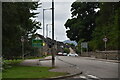
Welcome to Kingussie
Heading WSW towards the town
Image: © Kenneth Allen
Taken: 29 Apr 2009
0.11 miles