IMAGES TAKEN NEAR TO
KINGUSSIE, PH21 1NX
Introduction
This page details the photographs taken nearby to PH21 1NX by members of the Geograph project.
The Geograph project started in 2005 with the aim of publishing, organising and preserving representative images for every square kilometre of Great Britain, Ireland and the Isle of Man.

There are currently over 7.5m images from over14,400 individuals and you can help contribute to the project by visiting https://www.geograph.org.uk
Image Map
Images are licensed for reuse under creativecommons.org/licenses/by-sa/2.0
Notes
- Clicking on the map will re-center to the selected point.
- The higher the marker number, the further away the image location is from the centre of the postcode.
Image Listing (12 Images Found)
Images are licensed for reuse under creativecommons.org/licenses/by-sa/2.0
Image
Details
Distance
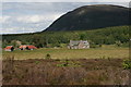
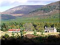
2
Tolvah, Glenfeshie
Farmhouse with derelict steading.
Image: © Dorothy Carse
Taken: 29 Jul 2009
0.01 miles
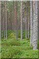
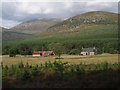
8
Track junction, Glen Feshie
South of the end of the public road on the east side of the glen are these motorable tracks. That to the left is heading to Tolvah, whilst straight ahead the main track continues for several miles serving various properties.
Image: © Gordon Hatton
Taken: 24 Apr 2022
0.20 miles
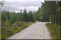
10
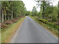
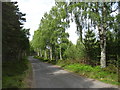
Woodland enclosed minor road heading in the direction of Balnascriten
Looking northward.
Image: © Peter Wood
Taken: 25 Sep 2020
0.23 miles