IMAGES TAKEN NEAR TO
Insh, KINGUSSIE, PH21 1NT
Introduction
This page details the photographs taken nearby to PH21 1NT by members of the Geograph project.
The Geograph project started in 2005 with the aim of publishing, organising and preserving representative images for every square kilometre of Great Britain, Ireland and the Isle of Man.

There are currently over 7.5m images from over14,400 individuals and you can help contribute to the project by visiting https://www.geograph.org.uk
Image Map
Images are licensed for reuse under creativecommons.org/licenses/by-sa/2.0
Notes
- Clicking on the map will re-center to the selected point.
- The higher the marker number, the further away the image location is from the centre of the postcode.
Image Listing (20 Images Found)
Images are licensed for reuse under creativecommons.org/licenses/by-sa/2.0
Image
Details
Distance
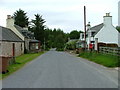
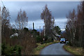
1
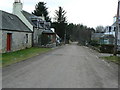
Insh
The main street of the hamlet of Insh.
Image: © James Allan
Taken: 11 Mar 2007
0.03 miles
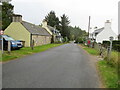
3
Insh
A very linear village on higher ground overlooking the marsh.
Image: © Richard Webb
Taken: 13 Sep 2014
0.04 miles
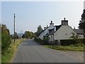
4
Houses at Insh
Insh settlement is situated south of Insh Marshes Nature Reserve.
Image: © Dave Fergusson
Taken: 15 Jun 2010
0.05 miles
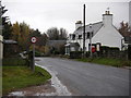
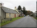
6
Insh
The village still has a telephone box.
Image: © Richard Webb
Taken: 13 Sep 2014
0.07 miles
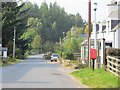
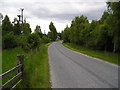
7
Road (B970) at Insh
Looking south-westward.
Image: © Peter Wood
Taken: 25 Sep 2020
0.08 miles
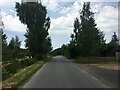
8
Insh Village
B970 road at Insh village.
Image: © edward mcmaihin
Taken: 24 Jan 2014
0.11 miles
9
Insh village from outside the Kirk
The south facing view through Insh village - the kirk out of view on the left and the Sollierie cottage off to the right.
Image: © Dean Molyneaux
Taken: 28 Jun 2009
0.14 miles