IMAGES TAKEN NEAR TO
Boa Vista Road, KINGUSSIE, PH21 1LE
Introduction
This page details the photographs taken nearby to Boa Vista Road, PH21 1LE by members of the Geograph project.
The Geograph project started in 2005 with the aim of publishing, organising and preserving representative images for every square kilometre of Great Britain, Ireland and the Isle of Man.

There are currently over 7.5m images from over14,400 individuals and you can help contribute to the project by visiting https://www.geograph.org.uk
Image Map
Images are licensed for reuse under creativecommons.org/licenses/by-sa/2.0
Notes
- Clicking on the map will re-center to the selected point.
- The higher the marker number, the further away the image location is from the centre of the postcode.
Image Listing (125 Images Found)
Images are licensed for reuse under creativecommons.org/licenses/by-sa/2.0
Image
Details
Distance
1
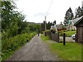
Boa Vista Road
Unsurfaced street in Kingussie. A dead end for motor traffic, but pedestrians can continue onto a network of footpaths by the Gynack Burn.
Image: © Callum Black
Taken: 3 Aug 2014
0.02 miles
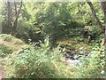
2

Gynack Burn by Tweed Mill
Snow-melt has raised the level with run-off.
Image: © Alan Reid
Taken: 12 Jan 2022
0.06 miles
3
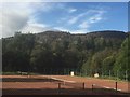
Kingussie Tennis Club
Courts above Kingussie. There is a path here which runs alongside the courts down to a bridge over the Gynack Burn.
Image: © Richard Webb
Taken: 23 Sep 2019
0.06 miles
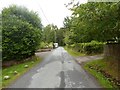
4
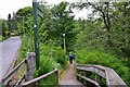
Path to the Gynack Burn, Kingussie
A path to a footbridge and walk up the E side of the burn past the site of former water-powered mills.
Image: © Jim Barton
Taken: 10 Jun 2016
0.07 miles

6
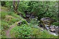
Old mill lade, Gynack Burn Kingussie
The old lade is to the left, once taking water to power mills further down. Kingussie was envisaged as a planned village by the Duke of Gordon in the late 18th century, in which water power from the Gynack Burn played a central part.
Image: © Jim Barton
Taken: 10 Jun 2016
0.10 miles
7
Kingussie Tennis Club
Courts available, £5 per hour.
Image: © Richard Webb
Taken: 23 Sep 2019
0.10 miles
8
Ruined dam, Gynack Burn
It provided the head of water needed for a flax mill.
Image: © Richard Webb
Taken: 23 Sep 2019
0.10 miles
9
Middle Terrace
A quiet street in Kingussie. At the west end of the street a track leads uphill to Creag Bheag.
Image: © Callum Black
Taken: 3 Aug 2014
0.13 miles
10
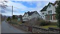
Fine houses on Gynack Road, Kingussie
Majestic semi-detached houses on this quiet side road.
Image: © Gordon Brown
Taken: 18 Apr 2018
0.14 miles