IMAGES TAKEN NEAR TO
High Street, KINGUSSIE, PH21 1JB
Introduction
This page details the photographs taken nearby to High Street, PH21 1JB by members of the Geograph project.
The Geograph project started in 2005 with the aim of publishing, organising and preserving representative images for every square kilometre of Great Britain, Ireland and the Isle of Man.

There are currently over 7.5m images from over14,400 individuals and you can help contribute to the project by visiting https://www.geograph.org.uk
Image Map
Images are licensed for reuse under creativecommons.org/licenses/by-sa/2.0
Notes
- Clicking on the map will re-center to the selected point.
- The higher the marker number, the further away the image location is from the centre of the postcode.
Image Listing (110 Images Found)
Images are licensed for reuse under creativecommons.org/licenses/by-sa/2.0
Image
Details
Distance
1
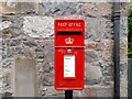
Post Box at Kingussie
PH21 48D. Royal Mail list this box as 'High Street (East)'.
Image: © David Bremner
Taken: 9 Jun 2022
0.01 miles
2
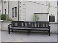
Seat, Kingussie
One of several located round the town, a close-up of the inscription is shown here Image]
Image: © Kenneth Allen
Taken: 29 Apr 2009
0.02 miles
4
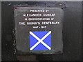
Inscription, seat at Kingussie
It is located here Image]
Image: © Kenneth Allen
Taken: 29 Apr 2009
0.02 miles
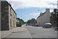
5
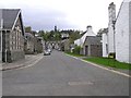
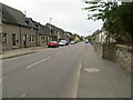
Duke Street, Kingussie
Looking northwards
Image: © Kenneth Allen
Taken: 29 Apr 2009
0.03 miles
7
"Ben Nevis", Kingussie
Pictured along High Street
Image: © Kenneth Allen
Taken: 29 Apr 2009
0.05 miles
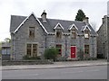
8

Black house, Highland Folk Museum
In a field between the kirk and railway.
Image: © Richard Webb
Taken: 7 Sep 2008
0.06 miles
9
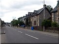
Kingussie main street
Formerly the A9, now the A86.
Image: © Dave Fergusson
Taken: 27 Dec 2009
0.06 miles
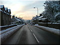
10
High Street (A86), Kingussie
Looking south-westward.
Image: © Peter Wood
Taken: 24 Sep 2020
0.06 miles