IMAGES TAKEN NEAR TO
Ruthven Road, KINGUSSIE, PH21 1ES
Introduction
This page details the photographs taken nearby to Ruthven Road, PH21 1ES by members of the Geograph project.
The Geograph project started in 2005 with the aim of publishing, organising and preserving representative images for every square kilometre of Great Britain, Ireland and the Isle of Man.

There are currently over 7.5m images from over14,400 individuals and you can help contribute to the project by visiting https://www.geograph.org.uk
Image Map
Images are licensed for reuse under creativecommons.org/licenses/by-sa/2.0
Notes
- Clicking on the map will re-center to the selected point.
- The higher the marker number, the further away the image location is from the centre of the postcode.
Image Listing (243 Images Found)
Images are licensed for reuse under creativecommons.org/licenses/by-sa/2.0
Image
Details
Distance
1
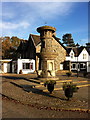
Mackenzie Fountain, Kingussie
Gifted to his native town by Peter Alexander Cameron Mackenzie, Count De Serra Largo of Tarlogie, and opened by The Countess of Serra Largo. 21st July 1911.
Image: © Andrew Abbott
Taken: 22 Oct 2012
0.02 miles
2
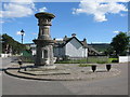
MacKenzie Fountain, Kingussie
The MacKenzie Fountain was gifted to his native town by Peter Alexander Cameron MacKenzie, Count de Serra Largo of Tarlogie, and opened by the Countess de Serra Largo on the 21st July 1911. It is located beside Kingussie railway station.
Image: © G Laird
Taken: 20 Jun 2017
0.02 miles
3
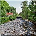
Railway bridge over the Gynack Burn
The Gynack Burn regularly runs in a spate, especially during periods of snowmelt, filling the river bed with boulders nearly up to the level of the bridge deck.
This results in the burn overflowing onto the railway line and on occasions the flood water has threatened the nearby Kingussie High School
Image: © valenta
Taken: 29 May 2018
0.02 miles
4
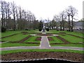
Memorial Garden, Kingussie
Looking SSE near the Duke of Gordon Hotel
Image: © Kenneth Allen
Taken: 29 Apr 2009
0.02 miles
6
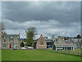
The Badenoch Centre
The Badenoch Centre Opened 2003 incorporating 2 buildings - the Victoria Hall, built in 1887 to commemorate Queen Victoria’s Golden Jubilee, and the Episcopal Church built in 1909. The Victoria Hall was used for many years as a picture house and concert hall. It was destroyed by fire in 1999 and subsequently re-emerged as the Badenoch Centre, which now provides sporting facilities, performance and function venues, a library, a youth room and a conference room.
Image: © John Allan
Taken: 17 May 2010
0.02 miles
7
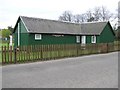
Kingussie Bowling Club
It is located along Spey Street. it was established in 1877
Image: © Kenneth Allen
Taken: 29 Apr 2009
0.02 miles
8
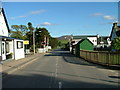
Level crossing on Ruthven road, Kingussie
Image: © Dave Fergusson
Taken: 14 Jun 2010
0.02 miles
9
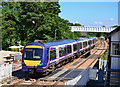
Train entering Kingussie station
The 12.47 Inverness - Edinburgh passenger service approaches Kingussie.
Image: © The Carlisle Kid
Taken: 27 Jul 2011
0.02 miles
10
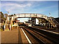
Kingussie railway station footbridge
Looking towards the level crossing.
Image: © Andrew Abbott
Taken: 22 Oct 2012
0.02 miles