IMAGES TAKEN NEAR TO
Ochil Gardens, PERTH, PH2 0SR
Introduction
This page details the photographs taken nearby to Ochil Gardens, PH2 0SR by members of the Geograph project.
The Geograph project started in 2005 with the aim of publishing, organising and preserving representative images for every square kilometre of Great Britain, Ireland and the Isle of Man.

There are currently over 7.5m images from over14,400 individuals and you can help contribute to the project by visiting https://www.geograph.org.uk
Image Map (Loading...)


Getting Data...Please wait
Leaflet Map data © OpenStreetMap
Images are licensed for reuse under creativecommons.org/licenses/by-sa/2.0
Notes
- Clicking on the map will re-center to the selected point.
- The higher the marker number, the further away the image location is from the centre of the postcode.
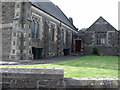
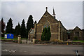
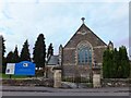
Image Listing (110 Images Found)
Images are licensed for reuse under creativecommons.org/licenses/by-sa/2.0
Image
Details
Distance
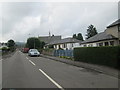
9
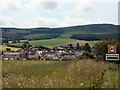
Entering Dunning
Entering Dunning on the B934 (Perth) road.
Image: © Lis Burke
Taken: 9 Jul 2005
0.13 miles
10
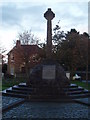
Dunning War Memorial
The building to the rear was the Union Bank and was closed as a bank in the 1960's.
Image: © Douglas Nelson
Taken: 6 Nov 2013
0.14 miles