IMAGES TAKEN NEAR TO
Lower Granco Street, PERTH, PH2 0SQ
Introduction
This page details the photographs taken nearby to Lower Granco Street, PH2 0SQ by members of the Geograph project.
The Geograph project started in 2005 with the aim of publishing, organising and preserving representative images for every square kilometre of Great Britain, Ireland and the Isle of Man.

There are currently over 7.5m images from over14,400 individuals and you can help contribute to the project by visiting https://www.geograph.org.uk
Image Map (Loading...)


Getting Data...Please wait
Leaflet Map data © OpenStreetMap
Images are licensed for reuse under creativecommons.org/licenses/by-sa/2.0
Notes
- Clicking on the map will re-center to the selected point.
- The higher the marker number, the further away the image location is from the centre of the postcode.
Image Listing (114 Images Found)
Images are licensed for reuse under creativecommons.org/licenses/by-sa/2.0
Image
Details
Distance
5
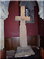
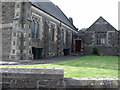
The Dupplin Cross, St Serfs Church
The Dupplin Cross is a rare and important survival, and as it is associated with a named king can be closely dated. One of the inscriptions refers to 'Constantine son of Fergus', who was king of the Picts from about AD789 to 820.
Image: © Maigheach-gheal
Taken: 14 Apr 2007
0.05 miles
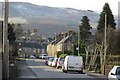
7
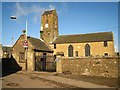
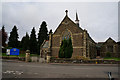
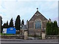
Dunning: St Serf's Church and watch-house
The tower of St Serf's Church dates to around 1200. The small building at the entrance to the graveyard was probably built as an offertory house but also served as a watch-house when grave-robbing was serious problem in the early 1800s. The watch-house is now used as an office by Historic Scotland.
Image: © Martyn Gorman
Taken: 19 Mar 2010
0.06 miles
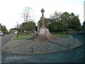
8
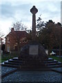
Dunning War Memorial
The building to the rear was the Union Bank and was closed as a bank in the 1960's.
Image: © Douglas Nelson
Taken: 6 Nov 2013
0.06 miles
10
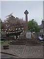
War Memorial, Dunning
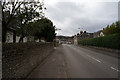
On the east side of Perth Road (B934).
Image: © Stanley Howe
Taken: 30 May 2013
0.06 miles