IMAGES TAKEN NEAR TO
Muckhart Road, PERTH, PH2 0RW
Introduction
This page details the photographs taken nearby to Muckhart Road, PH2 0RW by members of the Geograph project.
The Geograph project started in 2005 with the aim of publishing, organising and preserving representative images for every square kilometre of Great Britain, Ireland and the Isle of Man.

There are currently over 7.5m images from over14,400 individuals and you can help contribute to the project by visiting https://www.geograph.org.uk
Image Map
Images are licensed for reuse under creativecommons.org/licenses/by-sa/2.0
Notes
- Clicking on the map will re-center to the selected point.
- The higher the marker number, the further away the image location is from the centre of the postcode.
Image Listing (112 Images Found)
Images are licensed for reuse under creativecommons.org/licenses/by-sa/2.0
Image
Details
Distance
1
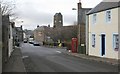
B934, Dunning
Looking towards St Serf's Church.
Image: © Richard Sutcliffe
Taken: 5 Dec 2017
0.07 miles
2
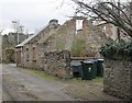
Ruined cottage and store, Thimblerow, Dunning
This roofless building is on the Buildings at Risk Register for Scotland [https://www.buildingsatrisk.org.uk/details/913709].
Image: © Richard Sutcliffe
Taken: 5 Dec 2017
0.07 miles
3
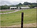
A serious fence
Outside Dunning - what's in the field, velociraptors?
Image: © Richard Webb
Taken: 24 Jun 2023
0.07 miles
4
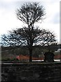
The Dunning Oak
Image: © David Purchase
Taken: 27 Nov 2012
0.08 miles
5
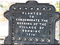
The Dunning Oak, descriptive plaque
This is the north side of the plaque. For the south side, see Image The oak itself is shown in Image
Image: © David Purchase
Taken: 27 Nov 2012
0.08 miles
6
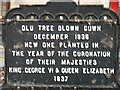
The Dunning Oak, descriptive plaque
This is the south side of the plaque. For the north side, see Image The oak itself is shown in Image
Image: © David Purchase
Taken: 27 Nov 2012
0.08 miles
7
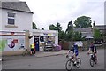
Dunning Post Office
Riders passing on a sportive. The cyclist at the shop is a tourist, running between Oban and Edinburgh and not part of an organised event. The event was a 100 mile circuit from Lochore to Dunning and back.
Image: © Richard Webb
Taken: 3 Jun 2018
0.08 miles
8
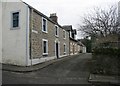
Thimblerow, Dunning
A group of Category C listed houses, just off Bridge of Earn Road.
Image: © Richard Sutcliffe
Taken: 5 Dec 2017
0.08 miles
9
Millhouse Farm, Dunning
Now also a depot for a transport company
Image: © Douglas Nelson
Taken: 6 Nov 2013
0.08 miles
10
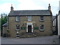
Kirkstyle Inn, Dunning
Large inn, built of sandstone, in the centre of the village. It faces the ancient Church of St Serf.
http://www.dunning.uk.net/
Image: © Colin Smith
Taken: 7 Jul 2010
0.08 miles