IMAGES TAKEN NEAR TO
Dunning, PERTH, PH2 0RE
Introduction
This page details the photographs taken nearby to PH2 0RE by members of the Geograph project.
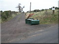
The Geograph project started in 2005 with the aim of publishing, organising and preserving representative images for every square kilometre of Great Britain, Ireland and the Isle of Man.

There are currently over 7.5m images from over14,400 individuals and you can help contribute to the project by visiting https://www.geograph.org.uk
Image Map
Images are licensed for reuse under creativecommons.org/licenses/by-sa/2.0
Notes
- Clicking on the map will re-center to the selected point.
- The higher the marker number, the further away the image location is from the centre of the postcode.
Image Listing (9 Images Found)
Images are licensed for reuse under creativecommons.org/licenses/by-sa/2.0
Image
Details
Distance
1
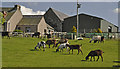
Goats at Middle Third Farm
A commercial herd rather than pets.
Image: © Iain A Robertson
Taken: 3 May 2011
0.03 miles
3
New builds at Middle Third
Looking downhill from the roadside to new houses at Middle Third, with Stùc a'Chroin and Ben Vorlich on the horizon to the left.
Image: © Scott Cormie
Taken: 16 Sep 2022
0.07 miles
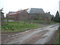
4
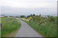
Road, Middle Third
The road out of Dunning over Clevage Hills.
Image: © Richard Webb
Taken: 3 Jun 2018
0.16 miles
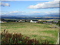
5
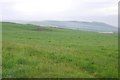
Field, Middle Third
Grassland above Dunning.
Image: © Richard Webb
Taken: 3 Jun 2018
0.17 miles
6
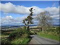
Steep brae near Guilds Wood
A view from the entrance to West Third Cottage's access road.
Image: © Alan O'Dowd
Taken: 28 Sep 2019
0.21 miles
7
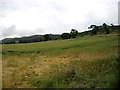
Near Guilds Wood
In the distance are the little-known Clevage Hills (square Image).
Image: © David Purchase
Taken: 6 Aug 2012
0.22 miles
8
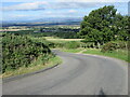
Twisty steep road above Dunning
Minor road twisting down from the Ochil Hills towards Dunning.
Image: © Scott Cormie
Taken: 16 Sep 2022
0.22 miles