IMAGES TAKEN NEAR TO
PERTH, PH2 0QF
Introduction
This page details the photographs taken nearby to PH2 0QF by members of the Geograph project.
The Geograph project started in 2005 with the aim of publishing, organising and preserving representative images for every square kilometre of Great Britain, Ireland and the Isle of Man.

There are currently over 7.5m images from over14,400 individuals and you can help contribute to the project by visiting https://www.geograph.org.uk
Image Map
Images are licensed for reuse under creativecommons.org/licenses/by-sa/2.0
Notes
- Clicking on the map will re-center to the selected point.
- The higher the marker number, the further away the image location is from the centre of the postcode.
Image Listing (9 Images Found)
Images are licensed for reuse under creativecommons.org/licenses/by-sa/2.0
Image
Details
Distance
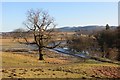
3
Boom Plantation
Woodland within a bend of the River Earn.
Image: © Richard Webb
Taken: 1 Feb 2015
0.11 miles
4
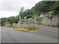
Entrance to Dupplin walled garden nursery
In the policies of Dupplin C.astle
Image: © James Denham
Taken: 24 Jul 2013
0.12 miles
5
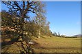
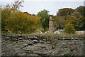
Below Dupplin Castle
Parkland grazing above the Earn. The walled garden is in the background.
Image: © Richard Webb
Taken: 1 Feb 2015
0.14 miles
6
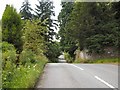
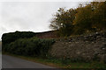
Tree-lined road by Dupplin estate
The wall on the right encloses the grounds of Dupplin Castle.
Image: © Lis Burke
Taken: 9 Jul 2005
0.14 miles
7
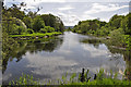
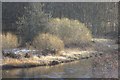
The River Earn looking to the Broom Plantation
The river looks very tranquil, but Strathearn is subject to extensive flooding on an annual basis.
Image: © Iain A Robertson
Taken: 20 May 2010
0.17 miles
8
Below Dupplin Castle
Fields beside the Earn.
Image: © Richard Webb
Taken: 1 Feb 2015
0.18 miles
