IMAGES TAKEN NEAR TO
Kingussie Road, NEWTONMORE, PH20 1DS
Introduction
This page details the photographs taken nearby to Kingussie Road, PH20 1DS by members of the Geograph project.
The Geograph project started in 2005 with the aim of publishing, organising and preserving representative images for every square kilometre of Great Britain, Ireland and the Isle of Man.

There are currently over 7.5m images from over14,400 individuals and you can help contribute to the project by visiting https://www.geograph.org.uk
Image Map
Images are licensed for reuse under creativecommons.org/licenses/by-sa/2.0
Notes
- Clicking on the map will re-center to the selected point.
- The higher the marker number, the further away the image location is from the centre of the postcode.
Image Listing (53 Images Found)
Images are licensed for reuse under creativecommons.org/licenses/by-sa/2.0
Image
Details
Distance
1
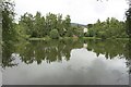
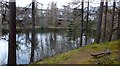
Loch Imrich, Newtonmore
Looking across the small loch found close to the middle of Newtonmore.
Image: © Graham Robson
Taken: 20 Jun 2018
0.05 miles
2
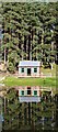
Newtonmore curling rink
The rink in summer, although in these days of global warming it is rarely cold enough to play the 'roaring game.'
Image: © John S Ross
Taken: Unknown
0.05 miles
3
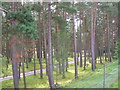
Caledonian Pine Wood
these trees lie inside the Newtonmore Folk Park. At one time, this was part of a Ladies' Golf Course! It is an area of kames.
Image: © Ailith Stewart
Taken: 15 Aug 2006
0.05 miles
6
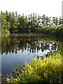
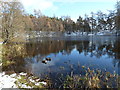
Loch Imrich
A tiny loch [lochan really] in a deep hollow just to the east of the main road through Newtonmore. I'm sure my old school physical geography book from decades ago would describe this as a 'kettle hole lake', ie - one that has formed in a hollow made by a lump of decaying ice.
Image: © Gordon Hatton
Taken: 25 Jul 2008
0.06 miles
7
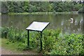
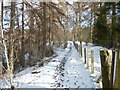
Loch Imrich, Newtonmore
The board informs that this is a kettle hole loch, water collecting in a hollow left by melting glacier ice. There are mallards on the pond plus the surfing cat shown in Image A path accessible from the main road circles the loch.
Image: © Jim Barton
Taken: 9 Sep 2013
0.06 miles
9
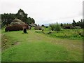
"Baile Gean" Township, Highland Folk Museum
A recreation of an early 1700s Highland township, based on evidence from survey and research at Easter Raitts.
Image: © Euan Nelson
Taken: 29 Aug 2015
0.06 miles
10
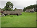
"Baile Gean" Township, Highland Folk Museum
This recreation of an early 1700s Highland township is based on archaeological research and documentary evidence of the settlement at Easter Raitts.
Image: © Euan Nelson
Taken: 29 Aug 2015
0.07 miles