IMAGES TAKEN NEAR TO
Calvine, PITLOCHRY, PH18 5UN
Introduction
This page details the photographs taken nearby to PH18 5UN by members of the Geograph project.
The Geograph project started in 2005 with the aim of publishing, organising and preserving representative images for every square kilometre of Great Britain, Ireland and the Isle of Man.

There are currently over 7.5m images from over14,400 individuals and you can help contribute to the project by visiting https://www.geograph.org.uk
Image Map
Images are licensed for reuse under creativecommons.org/licenses/by-sa/2.0
Notes
- Clicking on the map will re-center to the selected point.
- The higher the marker number, the further away the image location is from the centre of the postcode.
Image Listing (27 Images Found)
Images are licensed for reuse under creativecommons.org/licenses/by-sa/2.0
Image
Details
Distance
2
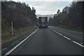
Perth and Kinross : The A9
Looking along the A9.
Image: © Lewis Clarke
Taken: 25 Apr 2016
0.05 miles
3
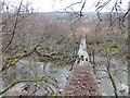
Ruined bridge, Clunes Lodge
Probably rendered redundant by the new forest on the opposite bank of the Garry, the bridge has been left to rot.
Image: © Richard Webb
Taken: 2 Apr 2014
0.08 miles
5
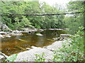
Footbridge over River Garry
The bridge has seen better days, much better days!
Image: © Russel Wills
Taken: 21 Jun 2009
0.08 miles
6
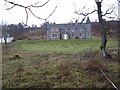
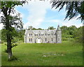
Clunes Lodge
From the heyday of the Highland sporting estate, the mid 19th century, this lodge is let out on a long term basis by Atholl Estates. It serves the deer forest to the north, a vast area of moorland with few significant summits.
Image: © Richard Webb
Taken: 19 Nov 2006
0.09 miles
7
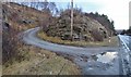
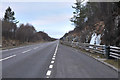
Access to the hill from Clunes Lodge
A9 traffic rushes past.
Image: © Alan Reid
Taken: 11 Dec 2016
0.10 miles
8
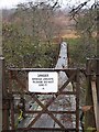
Bridge over the Garry - Clunes Lodge
Many advisory notices cry wolf - but this one means it! Many of the old suspension bridges are rotting away now.
The river is often easy to ford, as the Hydro take most of the water. When this bridge was built it would have been a vital link, the far bank would have been inhabited then too.
Image: © Richard Webb
Taken: 4 Nov 2006
0.11 miles
9
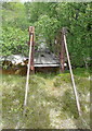
Dilapidated foot bridge over River Garry
From the south side there is no warning sign. See Richard Webb's http://www.geograph.org.uk/photo/282393. Being on the 'wrong' side and wanting to keep my other foot dry I gingerly crossed over. With farmers being given funds to 'manage' the countryside this bridge warrants proper maintenance or being replaced with a new 'safe' bridge.
Image: © Russel Wills
Taken: 21 Jun 2009
0.11 miles
10
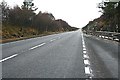
An Unusual View of the A9
The unusual thing about this view of the A9 is that there isn't a single vehicle on it. The road is usually inadequate for the volume of traffic it carries, because most of it is only a single carriageway and constant oncoming traffic means that overtaking opportunities are rare. I would have taken it from the centre line, but there was one car coming from the south which, had I taken the time to walk into the middle of the road, would have spoiled the shot!
Image: © Anne Burgess
Taken: 23 Jan 2010
0.11 miles