IMAGES TAKEN NEAR TO
Blair Atholl, PITLOCHRY, PH18 5TY
Introduction
This page details the photographs taken nearby to PH18 5TY by members of the Geograph project.
The Geograph project started in 2005 with the aim of publishing, organising and preserving representative images for every square kilometre of Great Britain, Ireland and the Isle of Man.

There are currently over 7.5m images from over14,400 individuals and you can help contribute to the project by visiting https://www.geograph.org.uk
Image Map (Loading...)


Getting Data...Please wait
Leaflet Map data © OpenStreetMap
Images are licensed for reuse under creativecommons.org/licenses/by-sa/2.0
Notes
- Clicking on the map will re-center to the selected point.
- The higher the marker number, the further away the image location is from the centre of the postcode.
Image Listing (17 Images Found)
Images are licensed for reuse under creativecommons.org/licenses/by-sa/2.0
Image
Details
Distance
1
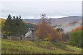
Croftmore, Glen Tilt
A small farmhouse on the lower slopes of Meall Dail Min.
Image: © Jim Barton
Taken: 3 Nov 2016
0.00 miles
2
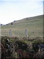
Croftmore, Glen Tilt
Grazing land below Meall Dail Min.
Image: © Dorothy Carse
Taken: 11 Mar 2012
0.02 miles
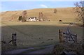
3
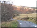
Croftmore from the new road
The old Mounth road runs across the hillside above the farmstead - apart from a few walkers and mountain bikers, almost all the traffic now uses the main track in the valley beside the River Tilt.
Image: © Richard Law
Taken: 2 Oct 2009
0.02 miles
4
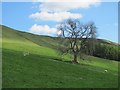
Field below Croftmore
Improved grassland with scattered trees in the lower part of Glen Tilt.
Image: © Richard Webb
Taken: 2 May 2011
0.07 miles
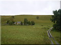
5
Croftmore
Farmland in Glen Tilt, view from the road. The old Mounth road can be seen running across the hillside above the farm.
Image: © Richard Webb
Taken: 15 Nov 2008
0.10 miles
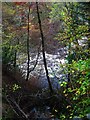
7
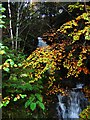
Waterfall, Glen Tilt.
Unnamed burn dropping to the River Tilt.
Image: © Richard Webb
Taken: 29 Oct 2005
0.16 miles
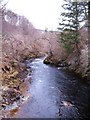
8
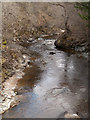
River Tilt upstream
The River Tilt as seen looking north from the Cumhann-leum Bridge.
Image: © Trevor Littlewood
Taken: 18 Apr 2008
0.17 miles
9
River Tilt.
Fast flowing river draining much of the Mounth. Taken from the road up the glen.
Image: © Richard Webb
Taken: 29 Oct 2005
0.17 miles
10
River Tilt
Looking upstream from Cumhann-leum bridge.
Image: © Gordon Hatton
Taken: 25 Mar 2010
0.18 miles