IMAGES TAKEN NEAR TO
Rannoch, PITLOCHRY, PH17 2QW
Introduction
This page details the photographs taken nearby to PH17 2QW by members of the Geograph project.
The Geograph project started in 2005 with the aim of publishing, organising and preserving representative images for every square kilometre of Great Britain, Ireland and the Isle of Man.

There are currently over 7.5m images from over14,400 individuals and you can help contribute to the project by visiting https://www.geograph.org.uk
Image Map
Images are licensed for reuse under creativecommons.org/licenses/by-sa/2.0
Notes
- Clicking on the map will re-center to the selected point.
- The higher the marker number, the further away the image location is from the centre of the postcode.
Image Listing (19 Images Found)
Images are licensed for reuse under creativecommons.org/licenses/by-sa/2.0
Image
Details
Distance
2
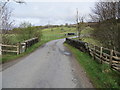
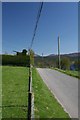
Road (B846) and bridge crossing Killichonan Burn
Looking north-westward.
Image: © Peter Wood
Taken: 28 Apr 2019
0.02 miles
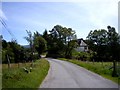
4
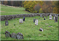
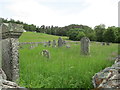
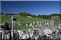
Cemetery at Killichonan
Killichonan is a small settlement on the north side of Loch Rannoch; the cemetery is adjacent to the B846.
Image: © Trevor Littlewood
Taken: 23 Oct 2012
0.06 miles
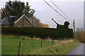
6
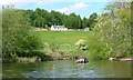
Topiary lion
A green lion looking out over Loch Rannoch
Image: © Dan
Taken: 8 May 2008
0.07 miles
9
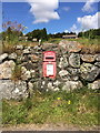
Killichonan Post Box
George VI postbox - letters only, cemented into dry stone dyke with inscription "1948" inscribed into cement when wet by builder.
Image: © Dougie Elder
Taken: 15 Jul 2015
0.08 miles