IMAGES TAKEN NEAR TO
Rannoch, PITLOCHRY, PH17 2QH
Introduction
This page details the photographs taken nearby to PH17 2QH by members of the Geograph project.
The Geograph project started in 2005 with the aim of publishing, organising and preserving representative images for every square kilometre of Great Britain, Ireland and the Isle of Man.

There are currently over 7.5m images from over14,400 individuals and you can help contribute to the project by visiting https://www.geograph.org.uk
Image Map
Images are licensed for reuse under creativecommons.org/licenses/by-sa/2.0
Notes
- Clicking on the map will re-center to the selected point.
- The higher the marker number, the further away the image location is from the centre of the postcode.
Image Listing (16 Images Found)
Images are licensed for reuse under creativecommons.org/licenses/by-sa/2.0
Image
Details
Distance
1
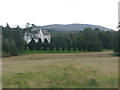
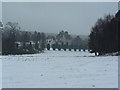
Dall House
A romantically styled Scots Baronial mansion house designed by architect Thomas Mackenzie. Prior to being purchased by Rannoch School, it was used as offices by the Forestry Commission.
The current owner had ambitious proposals to transform one of the most remote stretches of Highland Perthshire into a £1.3 billion private playground for the world's super-rich. Members of Perth and Kinross Council voted at a special meeting, in June 2010, to throw out controversial plans for the Dall Estate on the shores of Loch Rannoch.
Image: © Russel Wills
Taken: 14 Sep 2011
0.00 miles
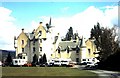
2
Dall House
Victorian mansion which for many years was the home of Rannoch School. Now in private hands and part of an estate that offers holiday cottages.
Image: © Gordon Hatton
Taken: 29 Mar 2009
0.03 miles
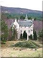
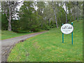
4
Dall House
This mansion was built in 1855 for the chief of the Robertsons of Struan. It was soon sold and had several owners including the Forestry Commission. More recently it was Rannoch School but, sadly, that closed in 2002. An idyllic location with the Black Wood of Rannoch on its doorstep, its own short golf course and the loch on which to teach sailing. The school ran an auxiliary fire service and mountain rescue team for the area. Photo was taken during the 2000 Jan Kjellestrom orienteering competition which was centred here.
Image: © ronnie leask
Taken: Unknown
0.07 miles
5
Dall House
The last time I passed along this road (a warm summer's day) this was part of Rannoch School, but after it closed in 2002 (ish) it is now Dall House.
Image: © Alan Stewart
Taken: 13 Mar 2006
0.07 miles
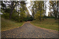
6
The start of the path
The start (and the end) of the path to Glen Lyon from Glen Rannoch
Image: © Graeme Smith
Taken: 26 Aug 2020
0.11 miles
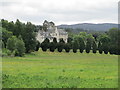
7

Hay field, Dall
In front of the house, once Rannoch School, now centre of controversial plans for a rich people reserve including a golf course. Earth to Plutocrats - protected Caledonian forest, anti getorfmoiland laws etc....
Image: © Richard Webb
Taken: 26 Jul 2008
0.11 miles
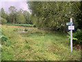
9
Dall Estate
'No unauthorised access - Private'
Not quite what the Access Code to the countryside envisaged.
Image: © Russel Wills
Taken: 14 Sep 2011
0.16 miles
10
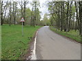
Road and Bridge crossing Dall Burn at Dall
Looking westward.
Image: © Peter Wood
Taken: 28 Apr 2019
0.19 miles