IMAGES TAKEN NEAR TO
Bridge Of Gaur, Rannoch, PITLOCHRY, PH17 2QE
Introduction
This page details the photographs taken nearby to PH17 2QE by members of the Geograph project.
The Geograph project started in 2005 with the aim of publishing, organising and preserving representative images for every square kilometre of Great Britain, Ireland and the Isle of Man.

There are currently over 7.5m images from over14,400 individuals and you can help contribute to the project by visiting https://www.geograph.org.uk
Image Map
Images are licensed for reuse under creativecommons.org/licenses/by-sa/2.0
Notes
- Clicking on the map will re-center to the selected point.
- The higher the marker number, the further away the image location is from the centre of the postcode.
Image Listing (23 Images Found)
Images are licensed for reuse under creativecommons.org/licenses/by-sa/2.0
Image
Details
Distance
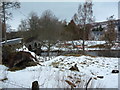
3
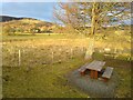
Picnic table in Bridge of Gaur
The little parking area next to the village hall has a decent tree, a picnic table, and lovely views across the glen. It is a convenient starting place for a number of interesting walks, in an area that is not rich in convenient parking.
Image: © Aleks Scholz
Taken: 27 Dec 2021
0.03 miles
5
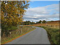
South Loch Rannoch road
Looking east along the road from near Bridge of Gaur.
Image: © Gordon Hatton
Taken: 14 Oct 2020
0.05 miles
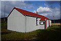
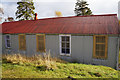
6
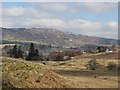
Bridge over the Allt an Fheadain
View down to Bridge of Gaur (that bridge is a far grander affair to the west). A scattered community with the Kirk of the Braes to the right (white building) The penstocks of Rannoch Power Station can be seen in the distance.
Image: © Richard Webb
Taken: 24 Mar 2007
0.05 miles
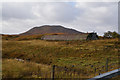
8
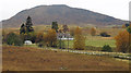
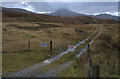
Moorland and minor road at Bridge of Gaur
A minor road leaves the B846 to pass through Bridge of Gaur then continues along the full length of the south side of Loch Rannoch. Meall Chomraidh is the background mountain.
(The photograph was taken from the Braes of Rannoch Parish Church where A.E. Robertson credited with being the first Munroist was once the minister.)
Image: © Trevor Littlewood
Taken: 23 Oct 2012
0.08 miles
9
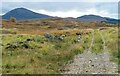
Hill track near Bridge of Gaur
Finnart Estate track heading across the moor. The 600m hill of Leagag is to the left.
Image: © Gordon Hatton
Taken: 14 Oct 2020
0.09 miles