IMAGES TAKEN NEAR TO
Croftinloan, PITLOCHRY, PH16 5TA
Introduction
This page details the photographs taken nearby to PH16 5TA by members of the Geograph project.
The Geograph project started in 2005 with the aim of publishing, organising and preserving representative images for every square kilometre of Great Britain, Ireland and the Isle of Man.

There are currently over 7.5m images from over14,400 individuals and you can help contribute to the project by visiting https://www.geograph.org.uk
Image Map
Images are licensed for reuse under creativecommons.org/licenses/by-sa/2.0
Notes
- Clicking on the map will re-center to the selected point.
- The higher the marker number, the further away the image location is from the centre of the postcode.
Image Listing (21 Images Found)
Images are licensed for reuse under creativecommons.org/licenses/by-sa/2.0
Image
Details
Distance
1
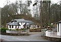
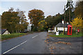
East Haugh
Driveway leading to Croftinloan which was a school, from the A9.
Image: © Richard Webb
Taken: 24 Feb 2007
0.07 miles
2
Route of General Wade's Military Road
Past Dalshian.
Image: © Russel Wills
Taken: 9 Nov 2010
0.11 miles
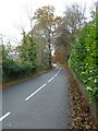
5
General Wade's Military Road towards Pitlochry
Image: © Ian S
Taken: 21 Oct 2014
0.14 miles
7
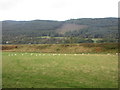
Sheep by the A9
Sheep in a field underneath the embankment of the A9 south of Pitlochry.
Image: © Scott Cormie
Taken: 2 Oct 2018
0.15 miles
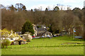
8
East Haugh
Ribbon development above the old A9.
Image: © Richard Webb
Taken: 24 Feb 2007
0.17 miles
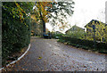
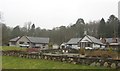
9

General Wade's Military Road
Looking northwest at East Haugh.
Image: © M J Richardson
Taken: 1 Feb 2019
0.18 miles
10
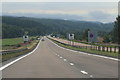
The A9 near East Haugh
Heading south.
Image: © Andrew Abbott
Taken: 17 Aug 2020
0.18 miles