IMAGES TAKEN NEAR TO
Strathtummel, PITLOCHRY, PH16 5RU
Introduction
This page details the photographs taken nearby to PH16 5RU by members of the Geograph project.
The Geograph project started in 2005 with the aim of publishing, organising and preserving representative images for every square kilometre of Great Britain, Ireland and the Isle of Man.

There are currently over 7.5m images from over14,400 individuals and you can help contribute to the project by visiting https://www.geograph.org.uk
Image Map
Images are licensed for reuse under creativecommons.org/licenses/by-sa/2.0
Notes
- Clicking on the map will re-center to the selected point.
- The higher the marker number, the further away the image location is from the centre of the postcode.
Image Listing (7 Images Found)
Images are licensed for reuse under creativecommons.org/licenses/by-sa/2.0
Image
Details
Distance
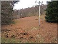
1
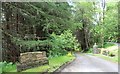
Ride, Port-an-Eilean
Rhododendron choked gap left for an electricity supply.
Image: © Richard Webb
Taken: 4 May 2013
0.08 miles
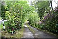
5
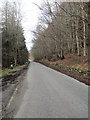
Ride, near Port-an-Eilean
A gap in the trees carrying a power line.
Image: © Richard Webb
Taken: 4 May 2013
0.11 miles
7
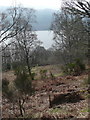
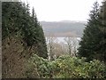
The north banks of Loch Tummel
Looking down from the B8019 through the woods to Loch Tummel.
Image: © Russel Wills
Taken: 3 Apr 2009
0.20 miles