IMAGES TAKEN NEAR TO
Dunalastair, PITLOCHRY, PH16 5PD
Introduction
This page details the photographs taken nearby to PH16 5PD by members of the Geograph project.
The Geograph project started in 2005 with the aim of publishing, organising and preserving representative images for every square kilometre of Great Britain, Ireland and the Isle of Man.

There are currently over 7.5m images from over14,400 individuals and you can help contribute to the project by visiting https://www.geograph.org.uk
Image Map
Images are licensed for reuse under creativecommons.org/licenses/by-sa/2.0
Notes
- Clicking on the map will re-center to the selected point.
- The higher the marker number, the further away the image location is from the centre of the postcode.
Image Listing (12 Images Found)
Images are licensed for reuse under creativecommons.org/licenses/by-sa/2.0
Image
Details
Distance
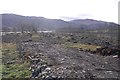
4
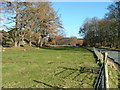
Drumglas
Sheep pasture beneath Beinn a' Chuallaich.
Image: © Richard Webb
Taken: 23 Dec 2018
0.15 miles
5
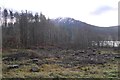
Restored view
Felling has revealed a view of Schiehallion from the B846.
Image: © Richard Webb
Taken: 23 Dec 2018
0.15 miles
6
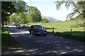
Rally, B847
Classic cars passing by at the junction with the B846 east of Kinloch Rannoch.
Image: © Richard Webb
Taken: 27 May 2018
0.15 miles
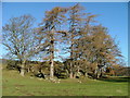
7
Trees and the Road to Trinafour
East of Kinloch Rannoch.
Image: © Dave Fergusson
Taken: 2 Feb 2007
0.15 miles
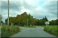
9
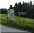
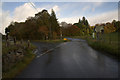
Junction of B847 and B846
Signs to help the tourists.
Image: © Russel Wills
Taken: 10 Aug 2009
0.17 miles
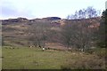
10
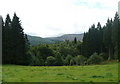
Grazing and forests south of B846
The distant hills, across Dunalastair Water, are the foothills of Schiehallion which is in the mist.
Image: © Russel Wills
Taken: 10 Aug 2009
0.19 miles