IMAGES TAKEN NEAR TO
Dunalastair, PITLOCHRY, PH16 5PB
Introduction
This page details the photographs taken nearby to PH16 5PB by members of the Geograph project.
The Geograph project started in 2005 with the aim of publishing, organising and preserving representative images for every square kilometre of Great Britain, Ireland and the Isle of Man.

There are currently over 7.5m images from over14,400 individuals and you can help contribute to the project by visiting https://www.geograph.org.uk
Image Map
Images are licensed for reuse under creativecommons.org/licenses/by-sa/2.0
Notes
- Clicking on the map will re-center to the selected point.
- The higher the marker number, the further away the image location is from the centre of the postcode.
Image Listing (9 Images Found)
Images are licensed for reuse under creativecommons.org/licenses/by-sa/2.0
Image
Details
Distance
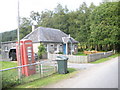
3
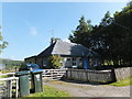
One storey house and telephone kiosk, Drumglas
Image: © nick macneill
Taken: 8 Sep 2011
0.08 miles
6
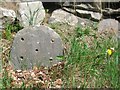
Old Milestone by the B846, north of Dunalastair Water
By the B846, in parish of Fortingall (District), Dunalastair Water, just West of the Old Post Office.
Inscription once read:- : Kinloch Rannoch / 3 : : Tummel Bridge / 4 :
Surveyed
Milestone Society National ID: PK_TBRS04.
Image: © Milestone Society
Taken: Unknown
0.20 miles
7
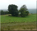
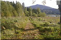
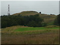
Trees growing where rock prevents cultivation
Image: © Russel Wills
Taken: 10 Aug 2009
0.23 miles
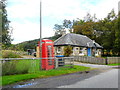
8
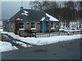
The Old Post Office
The map refers to an old schoolhouse but, according to the name plate, this is the old post office, beside the phone box.
Image: © Alan Stewart
Taken: 13 Mar 2006
0.24 miles
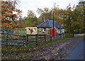
9
Reeds, grass and Trees
Plus a pylon of course in this area, and the hill Creagan na Leacainn.
Image: © Russel Wills
Taken: 10 Aug 2009
0.24 miles