IMAGES TAKEN NEAR TO
Killiecrankie, PITLOCHRY, PH16 5LR
Introduction
This page details the photographs taken nearby to PH16 5LR by members of the Geograph project.
The Geograph project started in 2005 with the aim of publishing, organising and preserving representative images for every square kilometre of Great Britain, Ireland and the Isle of Man.

There are currently over 7.5m images from over14,400 individuals and you can help contribute to the project by visiting https://www.geograph.org.uk
Image Map
Images are licensed for reuse under creativecommons.org/licenses/by-sa/2.0
Notes
- Clicking on the map will re-center to the selected point.
- The higher the marker number, the further away the image location is from the centre of the postcode.
Image Listing (21 Images Found)
Images are licensed for reuse under creativecommons.org/licenses/by-sa/2.0
Image
Details
Distance
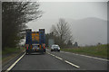
3
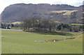
Mound with trees beside A9
This apparently man made structure is closely bypassed by the A9. Craig Fonvuick in the background.
Image: © Russel Wills
Taken: 2 Apr 2008
0.10 miles
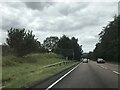
4
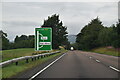
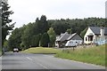
Perth and Kinross The A9
Looking along the A9.
Image: © Lewis Clarke
Taken: 25 Apr 2016
0.10 miles
6
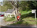
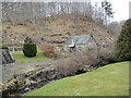
Atholl Cottage, Aldclune
Small cottage in a small hamlet
Image: © Graeme Smith
Taken: 25 Apr 2011
0.14 miles
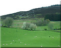
9
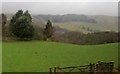
The Garry and The Retreat
On the B8079 just outside of Killiecrankie.
Image: © Andrew Abbott
Taken: 16 Aug 2020
0.16 miles